Bollandsås, O.M., K.H. Hanssen, S. Marthiniussen, and E. Næsset.
2008. Measures of spatial forest structure derived from airborne
laser data are associated with natural regeneration patterns in
an uneven-aged spruce forest,
Forest Ecology and Management
,
255(3-4):953–961.
Clark, M., 2013. A comparison of correlation measures, Michael
Clark’s personal webpage,
Center for Social Research, University of Notre Dame, URL:
https://
www3.nd.edu/~mclark19
(last accessed: May 2015).
Filosi, M., R. Visintainer, and D. Albanese, 2014. Minerva: Maximal
Information-based nonparametric exploration, R package version
1.4.1, URL:
(last
date accessed: 20 March 2017).
Flaherty, S., P.W.W. Lurz, and G. Patenaude. 2012. Implementation
of a general linear model using LiDAR derived explanatory
variables: A case study in Scotland,
Proceedings of the
Conference on Remote Sensing for Agriculture, Ecosystems,
and Hydrology XIV, in association with the 19
th
International
Symposium on Remote Sensing
, Edinburgh, Scotland.
Garcia, M., D. Riano, E. Chuvieco, and F.M. Danson. 2010. Estimating
biomass carbon stocks for a Mediterranean forest in central
Spain using LiDAR height and intensity data,
Remote Sensing of
Environment
, 114(4):816–830. doi: 10.1016/j.rse.2009.11.021.
González-Ferreiro, E, D Miranda, L Barreiro-Fernandez, S Bujan, J
Garcia-Gutierrez, and U Dieguez-Aranda. 2013. Modelling stand
biomass fractions in galician eucalyptus globulus plantations
by use of different LiDAR pulse densities,
Forest Systems
,
22(3):510–525. doi:10.5424/fs/2013223-03878.
Hudak, A.T., N.L. Crookston, J.S. Evans, M.J. Falkowski, A.M.S.
Smith, P.E. Gessler, and P.
Morgan, 2006. Regression modelling and mapping of coniferous
forest basal area and tree density from discrete-return lidar
and multispectral satellite data,
Canadian Journal of Remote
Sensing
, 32(2):126–138.
Hudak, A.T., N.L. Crookston, J.S. Evans, D.E. Hall, and M.J.
Falkowski. 2008. Nearest neighbor imputation of species-level,
plot-scale forest structure attributes from LiDAR data,
Remote
Sensing of Environment
, 112(5):2232–2245. doi: 10.1016/
j.rse.2007.10.009.
Hyyppa, J., X.W. Yu, H. Hyyppa, M. Vastaranta, M. Holopainen, A.
Kukko, H. Kaartinen, A. Jaakkola, M. Vaaja, J. Koskinen, and
P. Alho. 2012. Advances in forest inventory using airborne
laser scanning,
Remote Sensing
, 4(5):1190–1207. doi: 10.3390/
rs4051190.
Jensen, J.L.R., K.S. Humes, T. Conner, C.J. Williams, and J. DeGroot.
2006. Estimation of biophysical characteristics for highly
variable mixed-conifer stands using small-footprint lidar,
Canadian Journal of Forest Research-Revue Canadienne De
Recherche Forestiere
, 36(5):1129–1138. doi: 10.1139/x06-007.
Korhonen, L., I. Korpela, J. Heiskanen, and M. Maltamo, 2011.
Airborne discrete-return LIDAR data in the estimation of
vertical canopy cover, angular canopy closure and leaf area
index,
Remote Sensing of Environment
, 115(4):1065–1080. doi:
10.1016/j.rse.2010.12.011.
Kraus, K., and N. Pfeifer, 1998. Determination of terrain models in
wooded areas with airborne laser scanner data,
ISPRS Journal
of Photogrammetry and Remote Sensing
53(4):193–203. doi:
10.1016/s0924-2716(98)00009-4.
Linfoot, E.H., 1957. An informational measure of correlation,
.
Information and Control
, 1:85–89.
Magnussen, S., and P. Boudewyn, 1998. Derivations of stand heights
from airborne laser scanner data with canopy-based quantile
estimators,
Canadian Journal of Forest Research
, 28(7):1016–
1031. doi: 10.1139/x98-078.
Maltamo, M., K. Eerikäinen, P. Packalén, and J. Hyyppä. 2006.
Estimation of stem volume using laser scanning-based canopy
height metrics,
Forestry
, 79(2):217–229. doi:10.1093/forestry/
cpl007.
Maltamo M., E. Næsset, and J. Vauhkonen (editors), 2014.
Forestry
Applications of Airborne Laser Scanning, Concepts and
Case Studies
, Managing Forest Ecosystems Series
,
Springer,
Dordrecht.
McGaughey, R.J. 2013.
FUSION/LDV
,
Software for LiDAR Data
Analysis and Visualization
, USDA/Forest Service.
Montaghi, A., P. Corona, M. Dalponte, D. Gianelle, G. Chirici, and
H. Olsson 2013, Airborne laser scanning of forest resources:
An overview of research in Italy as a commentary case study,
International Journal of Applied Earth Observation and
Geoinformation
, 23:288–300.
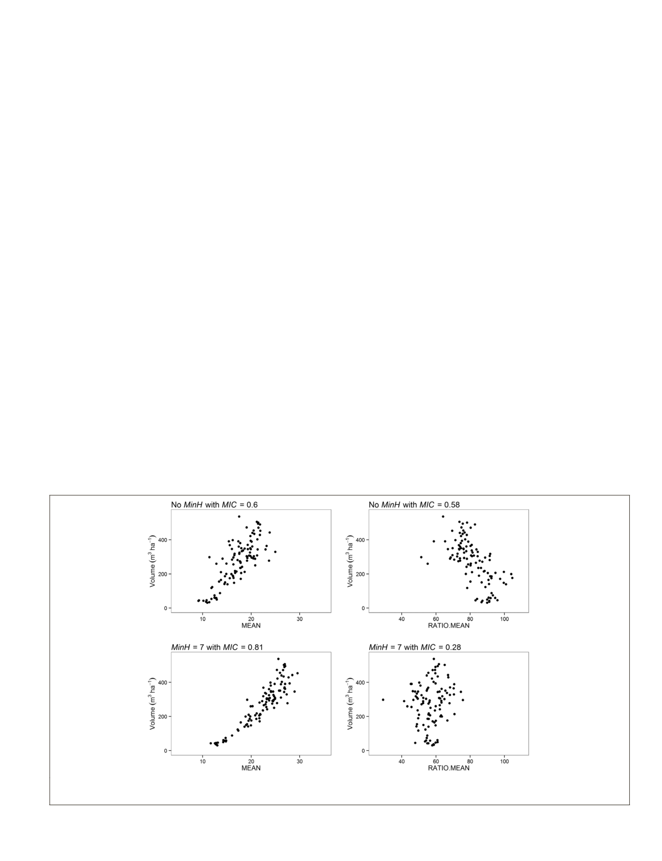
Figure 5. Scatterplots of the relationship Volume ~MEAN on the left and Volume ~RATIO.MEAN on the right, where upper
graphs indicate the extracted metric in absence of
HREF
,
and lower graphs indicate the HMEAN extracted with
HREF
= 7 meters.
PHOTOGRAMMETRIC ENGINEERING & REMOTE SENSING
May 2017
349


