Conclusions
To solve the problems of large-area controlled seamless
DOM
production using
LROC NAC
images, a systematic method consist-
ing of two stages of data processing is developed in this study.
First, the
RFM
-based planar block adjustment is used to improve
the relative positional consistencies of the
LROC NAC
images to
the subpixel level and at the same time tie the
NAC
images to the
control source (
SLDEM2015
). Second, a
TPS
-based image registra-
tion is used to reduce the geometric inconsistencies between
two neighboring subarea
DOM
mosaics and ensures final
DOM
being seamlessly mosaicked throughout the entire area.
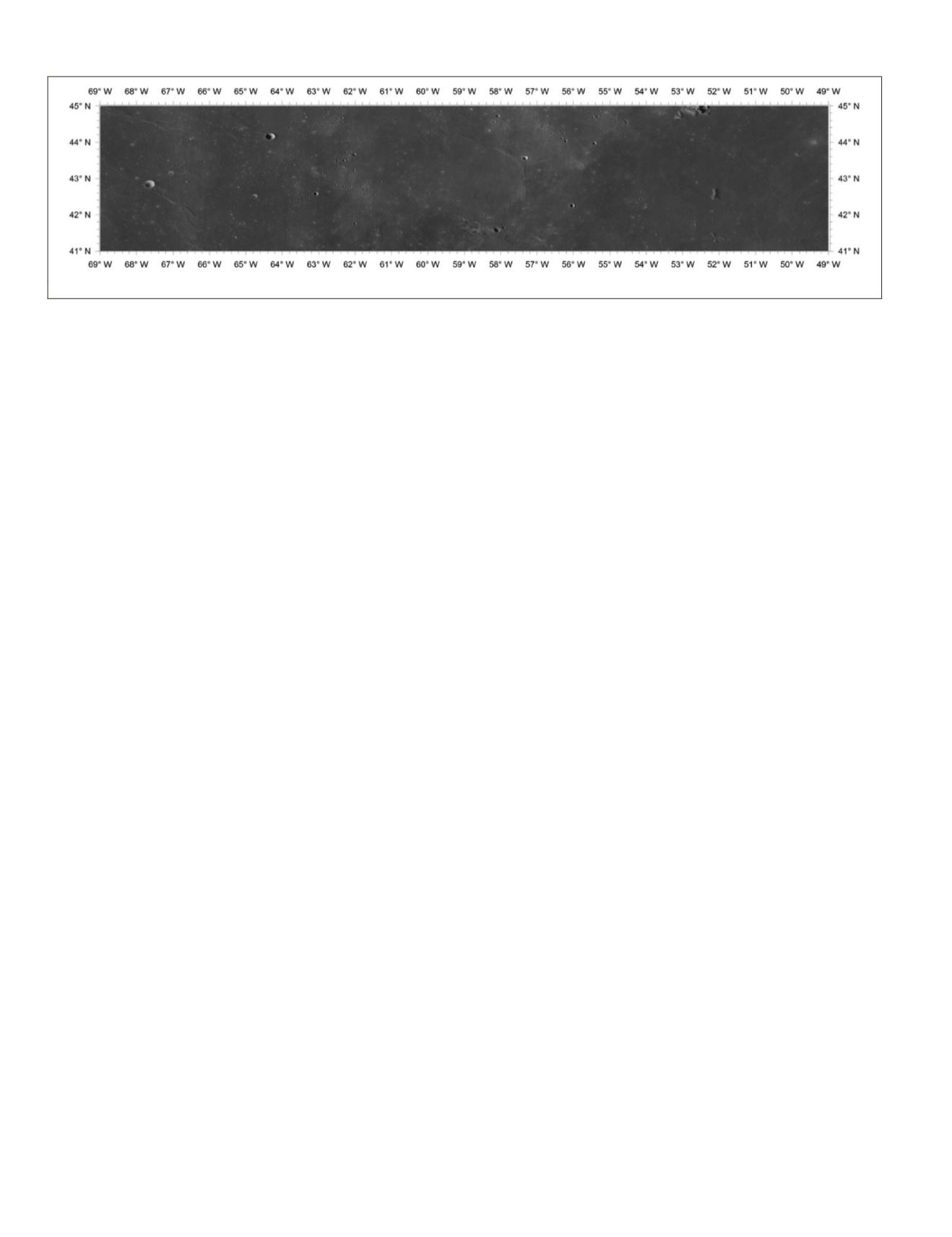
A high-resolution seamless
DOM
mosaic is produced with
the proposed two-stage method for the Chang’e-5 planned
landing area using 765
NAC
images. Consequently, the tie
point RMS errors are all approximately one-half pixel, show-
ing satisfactory geometric consistencies among
NAC
images.
The control point RMS errors were approximately one grid
cell size of
SLDEM2015
, which means that the produced
DOM
has been registered to
SLDEM2015
with high precision. After
DOM
registration with the
TPS
model, the planar precision is
mostly smaller than one pixel in the output
DOM
. The resul-
tant
DOM
mosaic, covering 49
°
–69
°
west longitude and 41
°
–45
°
north latitude, has an image size of 224 721 columns
×
44 945
rows with a ground sample distance of 1.5 m.
resolution
DOM
is of great importance for detail
cal and geological analysis of the Chang’e-5 lan
developed method is applicable to high-resolut
other large areas on the lunar surface using
LROC NAC
images.
Acknowledgments
This work was supported by the Key Research Program of
the Chinese Academy of Sciences (grant no. XDPB11) and
the National Natural Science Foundation of China (grant nos.
41671458, 41590851, and 41771490). We thank all those who
worked on the Planetary Data System archive to make the
LRO
imagery and
SLDEM2015
publicly available.
References
Archinal B. A., E. Lee, L. Weller, J. Richie, K. Edmundson, M.
Robinson, E. Speyerer, A. K. Boyd, E. Bowman-Cisneros, R.
Wagner and A. V. Nefian. 2015. Status of geodetically controlled
high-resolution LROC polar mosaics. Page 1571 in
Proceedings
of 46th Lunar and Planetary Science Conference
, held in The
Woodlands, Tex., 16–20 March 2015.
Arizona State University. 2011. WAC Global Morphologic Map.
>
Accessed 10 April 2018.
Barker, M. K., E. Mazarico, G. A. Neumann, M. T. Zuber, J. Haruyama
and D. E. Smith. 2016. A new lunar digital elevation model from
the Lunar Orbiter Laser Altimeter and SELENE Terrain Camera.
Icarus
273:346–355.
Bart, G. D., R. D. Nickerson, M. T. Lawder and J. Melosh. 2011. Global
survey of lunar regolith thickness from LROC images.
Icarus
215(2):485–490.
Burns, K. N., E. J. Speyerer, M. S. Robinson, T. Tran, M. R. Rosiek,
B. A. Archinal and E. Howington-Kraus. 2012. Digital
elevation models and derived products from LROC NAC stereo
observations. Pages 483–488 in
Proceedings of 22nd Congress of
International Archives of the Photogrammetry, Remote Sensing
and Spatial Information Sciences—ISPRS Archives
, held in
Melbourne, Australia, 25 August–1 September 2012.
Data Publishing and Information Service System of China’ Lunar
Exploration Project. 2018. <
_
dataSearch.search> Accessed 2 July 2018.
Di, K., M. Jia, X. Xin, B. Liu, Z. Liu, M. Peng and Z. Yue. 2018. High
resolution seamless DOM generation over Chang’e-5 landing area
using LROC NAC images. Pages 271–276 in
Proceedings of 2018
ISPRS TC III Mid-term Symposium “Developments, Technologies
and Applications in Remote Sensing,”
held in Beijing, China,
7–10 May.
Di, K., Y. Liu, B. Liu, M. Peng and W. Hu. 2014. A self-calibration
bundle adjustment method for photogrammetric processing of
Chang’e-2 stereo lunar imagery.
IEEE Transactions on Geoscience
and Remote Sensing
52(9):5432–5442.
Di, K., S. Sun, Z. Yue and B. Liu. 2016. Lunar regolith thickness
om 3D morphology of small fresh craters.
Icarus
confirms landing site for Chang’e-5 Moon
ttps://gbtimes.com/china-confirms-landing-site-
change-5-moon-sample-return> Accessed 10 April 2018.
Gwinner, K., R. Jaumann, E. Hauber, H. Hoffman, C. Heipke, J. Oberst,
G. Neukum, V. Ansan, J. Bostelmann, A. Dumke, S. Elgner, G.
Erkeling, F. Fueten, H. Hiesinger, N. M. Hoekzema, E. Kersten,
D. Loizeau, K.-D. Matz, P. C. McGuire, V. Mertens, G. Michael, A.
Pasewaldt, P. Pinet, F. Preusker, D. Reiss, T. Roatsch, R. Schmidt,
F. Scholten, M. Spiegel, R. Stesky, D. Tirsh, S. van Gasselt, S.
Walter, M. Wählisch and K. Willner. 2016. The high resolution
stereo camera (HRSC) of Mars Express and its approach to
science analysis and mapping for Mars and its satellites.
Planetary and Space Science
126:93–138.
Gwinner, K., F. Scholten, F. Preusker, S. Elgner, T. Roatsch, M.
Spiegel, R. Schmidt, J. Oberst, R. Jaumann and C. Heipke.
2010. Topography of Mars from global mapping by HRSC
high-resolution digital terrain models and orthoimages:
Characteristics and performance.
Earth and Planetary Science
Letters
294(3):506–519.
Haase, I., J. Oberst, F. Scholten, M. Wählisch, P. Gläser, I.
Karachevtseva and M. S. Robinson. 2012. Mapping the Apollo 17
landing site area based on Lunar Reconnaissance Orbiter Camera
images and Apollo surface photography.
Journal of Geophysical
Research: Planets
117(E00H20):1–8.
Haase, I., M. Wählisch, P. Gläser, J. Oberst and M. S. Robinson. 2014.
Apollo 17 landing site: A cartographic investigation of the
Taurus-Littrow Valley based on LROC NAC imagery. Pages 1–12
in
Proceedings of European Planetary Science Congress
, held in
Cascais, Portugal 7–12 September 2014.
Figure 9. Produced seamless
DOM
mosaic of the Chang’e-5 planned landing area.
490
July 2019
PHOTOGRAMMETRIC ENGINEERING & REMOTE SENSING


