|
Product Information
Vendor
Pixoneer Corporation
7777 Leesburg Pike, Suite 7LS
Falls Church, VA 22043 USA
703-852-2162,
1-866-PIXONEER,
703-852-2170 (fax)
www.pixoneer.com
info@pixoneer.com
Hardware
Minimum Requirements:
Pentium II
64/128 Meg RAM
10/20GB Hard Drive
8 MB Graphics Card
Minimum Screen Resolution 800 x 600
Hardware Platforms Supported:
Intel Pentium or any 100% compatible computer (Pentium II with
MMX, Pentium III, Pentium IV, Pentium Pro, AMD, and Cyrix)
Software
Software runs on Windows 98, Windows
ME, Windows NT, and 2000
Program file size ~ 130 Meg
Tested Configuration
1.7Mhz Pentium IV with 1.0GB RAM
3Dlabs Wildcat II 5110 graphics card
Windows 2000 (sp2) |
Summary
Earth 2.0 from Pixoneer, Corp. is an image processing software
package for integrated image interpretation and analysis. The
software offers an easy-to-learn, icon-based interface with
a diverse suite of data management, analysis, and output functions.
The software contains numerous modules for the integration
of geospatial data from remote sensing, GIS, or GPS sources.
Provided preprocessing tools are comprehensive, including georectification,
orthorectification, atmospheric and radiometric normalization,
topographic correction, and synthetic aperture radar (SAR)
analysis. Mainstream image classification algorithms, including
supervised and unsupervised classification and editing capabilities
are also incorporated. Image enhancement tools include image
sharpening, spectral and color transformation, image algebra
and band math, and spatial and frequency filtering. Data import/export
tools are provided for other popular products such as ESRI
ArcGIS© and ArcView©, Erdas IMAGINE©, ER Mapper©,
ENVI©, and PCI©. In addition, raw satellite image
formats, GIS data, and generic binary and ASCII import/export
are available. Image manipulation and management tools allow
users to subset, mosaic, and composite scenes. A 3D viewer
provides for integration of terrain modeling and remote sensing,
including fly-thru visualization and orthographic perspectives
with raster and vector overlays. Map production tools are packaged
in a provided module, “iMapper.” Overall, the software
provides the tools for comprehensive image analysis from input,
preprocessing, enhancement, classification, visualization,
and output.
The Earth 2.0 software is available for trial use from the
vendor by download or CD-ROM upon request. This review tested
a standard
installation of the software using the provided sample data and
tutorial. In addition to these items, Pixoneer supplies a comprehensive
online help manual, user manual, and a forthcoming set of educational
modules for training. They also provide technical support and
publish a newsletter for users. To evaluate the robustness and
versatility of the software, external data in the author’s
possession was also imported and used to evaluate Earth 2.0.
Features
The focal point of the Earth 2.0 interface is an icon-based
menu window with buttons for accessing modular submenus and
analysis
functions. Each module of the software is accessed from the
main menu (Figure 1.) Each module has its own set of icons
for using
the relevant dialog boxes and tools. Most image display and
interpretive functions of the software are accessed in the
Visual Analyzer
window (Figure 2.)
|
|
Figure
1. Earth main menu window
|
|
|
| Figure
2. Visual Analyzer window with image file loaded (daejon.idm). |
Other submenus reflect the diverse analytical tools of the
overall package, including below:
- Image Processing
- Preprocessing Functions
- Geometric Correction
- Orthorectification
- Radiometric Normalization
- Topographic Correction
- Classification
- Supervised Classification
- Unsupervised Classification
- Feature Extraction by spectral and spatial reflectance
- Classification Editing
- Vectorization and GIS import/export
- Image Enhancement
- Image Sharpening
- Spectral and Color Transformation
- Image Algebra and Band Math
- Spatial and Frequency Filtering
- DEM Tools
- Stereo DEM generation and updating
- SAR image coregistration
- SAR interferogram generation and filtering
- SAR DEM generation
- Vector DEM rasterization
- DEM editor and interpolation
- DEM topographic modeling
- SAR Tools
- Header viewer
- SAR backscatter and db analysis
- Slant range and ground range extraction
- Antenna pattern correction
- Spatial and frequency filtering
- 3D Analyzer
- Scale tools
- Color palletes and histogram control
- 3D views
- Flying simulation
- Path and Line-of-sight analysis
- Background illumination
- Annotation and vector overlay
- BMP and AVI movie recording, export, and play
- iMAPPER Map Tools
- Interactive image map import or creation from Visual
Analyzer
- Graticule and scale bar tools
- Legend editor
- Color bars and north arrows
- Annotation and text
- WYSIWYG printing
Image Display
The Visual Analyzer provides a comprehensive set of tools for
image display, including handy on-screen windows for layer
organization and band-color assignment as well as display of
ground control points (GCPs) and regions of interest (ROIs.)
The Visual Analyzer works with IDM file format, a generic BSQ
(band sequential) binary format that can contain up to 256
bands with no size limit. Each IDM file has a paired IDX file
containing ancillary information (sensor, bands, coordinates
of the image, and such header information.) A status bar in
the viewer shows coordinate locations and pixel values as well
as the stretched screen display value. Quick enhancements are
accomplished easily from a pull-down menu on the viewer. These
include on-the-fly linear min-max stretches, Gaussian, and
histogram equalization. Viewer zoom tools are also positioned
along the top of the icon bar. One handy feature in the viewer
is a toggle button for a scale bar in the viewer. In the lower
left of the Visual Analyzer, a magnifier window (scroll window)
is positioned to allow the magnification of cursor areas or
to set the zoom. A layers contents list appears at the upper
left of the Visual Analyzer for quick manipulation of layer
color gun assignments and display of GCPs and ROIs.
In addition to pure display manipulation, the Visual Analyzer
window provides buttons along the icon bar for image statistics
and file size and structure, scattergrams, measurement tools,
and selection tools for GCPs and ROIs. Multiple viewers with
co-registered images may also be linked spatially, especially
useful in classification and interpretation, with simple execution
of a Link View button. The structure of the visual analyzer
is quite efficient, because it provides the most commonly used
tools
in conjunction with visual analysis without the need for navigating
extensive pull-down menus or dialog boxes. The only caveat
to the new user is that the interface provides icons without
the
redundant or optional use of a menu bar. Use of the analyzer
window improves rather quickly with practice since the button
icons use visually-keyed graphics. The overall result is an
ergonomically efficient image analysis window that maximizes
the available
desktop space and makes viewing and interpretation easy for
the learner and efficient in production and research applications.
Image
File Management
Earth 2.0 provides a slate of image file management
and manipulation tools. All file management
tools mentioned are accessible from
the main menu “Tools and Utilities” submenu. Vital
image import and export functionality includes common image formats
and some of special value to the scientific and engineering community.
The file information tab in the Visual Analyzer and corresponding
tool in the Tools and Utilities menu provide access to image
statistics, scattergrams, and a header editing dialog. Image
import supports five general categories of images with specific
file formats in each group. Satellite image formats pre-programmed
include AVHRR, ERS, IKONOS, IRS FAST, JERS-1, KOMPSAT, LANDSAT
(CEOS, FAST, HDF, MRLC, and NDF formats), RADARSAT, and SPOT).
HDF format is generic and allows import from various HDF-formatted
sensor data (e.g., Landsat, MODIS, ASTER, MISR, CERES, and MOPITT.)
Remote sensing imagery file formats include several common software
formats (ArcView© raster, ENVI©, Erdas© .IMG and
.LAN, and ERMAPPER© .ERS, and PCI© .PIX). Digital Elevation
Model (DEM) format importers include USGS DEM and STDS (Spatial
Data Transfer Standard), DMA DTED, and Lidar X,Y, Z. The latter
format opens a convenient dialog for specifying output file resolution,
size, and “no data” values. The list of export image
formats includes Erdas 7.5 .LAN (but not .IMG), PCI (.PIX), ERMAPPER
(.ERS), ENVI, and ArcView binary BIL. A set of generic binary
and ASCII output formats are also supported, including BIP, BIL,
and BSQ formatting. Finally, the export utility also provides
for TIFF and GeoTIFF formats as well as on-the-fly image subset
for export, including specifying a rectangular region of interest
to subset or band selection.
Prime image management utilities in Earth 2.0 include subset/resize
images, mosaic, layer manipulation, and map projection conversion.
Subsetting images is accomplished using a single dialog box from
the submenu button bar. This function supports three kinds of
georeferencing, nearest neighbor, bilinear interpolation, and
cubic convolution. The subsetting functionality here only supports
rectangular regions of interest. Mosaic processsing is subdivided
into spatial and spectral manipulation. Spatial mosaic refers
to the common task of integrating adjacent and/or overlapping
imagery or raster GIS data into a combined file. Two kinds of
spatial mosaic are included — georeferenced automatic positioning
or manual pixel-based selection (for non-georeferenced images.)
A special histogram adjustment tool can be enabled within the
software to adjust contrast for matching adjacent images in areas
of overlap. Map projection conversion is accomplished in a single
window interface from the “Tools and Utilities” submenu.
A powerful and straightforward tool, the projection conversion
works with most projections, coordinate systems, and datums in
contemporary use. Projection conversion allows either image warping
or point-by-point conversion. Over 250 projections and datums
are supported in this version, including a conversion utility
for point re-projection. In addition to re-sampling by nearest
neighbor, bilinear interpolation, and cubic convolution, the
coordinate conversion dialog allows on-the-fly subset and band
selection. For correction of badlines, line dropouts, “pits” in
DEMs, or other errors in raster data, the “Tools and Utilities” menu
contains a Pixel Editor. This tool provides easy access to the
actual pixel data to correct individual pixels, bad lines, or
portions of lines, and assists their correction with pre-programmed
averaging and user-specified substitution options.
Two rather
unique aspects of the Tools and Utilities in Earth 2.0 may interest
select users. One button on the menu provides
an algorithm for estimation of sun angle from user-specified
inputs (date, time, latitude, longitude) for calculation of solar
elevation and azimuth angles. This utility can be handy, for
example, in change detection and topographic normalization or
classification work. Another interesting utility is a button
for hyperlinks to Earth Observation imagery, the “EO Imagery
Search” button. This activates a window with hyperlinks
and a browser activation tool to connect and search several digital
satellite image providers. The tool has functions to update and
customize these links and lists common sensor resolutions and
spectral-orbital characteristics. With the advent of numerous
and ever-growing sensors, this utility could be very useful to
new users and those involved with diverse multisensor projects.
Image Processing and Classification
Image processing and classification functions are integrated
in the “Image Processing” submenu of Earth 2.0. These
functions include fundamental preprocessing and classification
functions, such as geometric correction (with GCP selection and
editing), radiometric and topographic correction, orthorectification,
supervised and unsupervised classification, feature extraction,
and band math. Spectral and spatial filtering algorithms, a classified
image editor, and vectorization button are also packaged in this
menu interface. The GCP (ground control point) Geometric Correction
tool allows selection or input of GCPs from keyboard entry, selection
from other rectified imagery, or from digital vector maps. The
user can save and modify GCP sets in both the input image and
a reference file in the case of master/slave rectification. Image
transformation tools, including multispectral enhancement and
color transforms, are grouped into a single interface. Unsupervised classification provides sequential, k-means, and
ISODATA algorithms. The parameters for each algorithm follow
published literature, such as specification of the number of
clusters, merger and splitting of clusters by size thresholds,
and maximum number of iterations. Cluster centroid distances
and means are reported iteratively as well as in the final output
stage. The functionality allows the user to run algorithms in
spatial subsets or to specify a select set of input bands.
Supervised classification incorporates six
algorithms: minimum distance to means, parallelpiped,
Mahalanobis, maximum likelihood,
spectral angle mapper, and neural network classification. For
all methods, interactive training set creation and editing is
incorporated. Scattergrams are visible within the same window
as principal editing and signature evaluation tools. The included
artificial neural network classifier is based on a backward-propagation
algorithm and includes three layers (input, hidden, and output)
with user-specified options including number of input nodes and
layers, and output classes.
Other functionality in the image processing
menu includes band math/algebra calculations,
radiometric and topographic correction,
multispectral image transformation, and spatial sharpening. Band
math tool uses a calculator-like interface to allow the user
to derive multispectral pixel variables. The interface has a
built-in conditional rule with a if-then-else rule structure.
The tool allows algebraic calculation with multiple input images.
Radiometric correction tools included in Earth 2.0 are based
on relative or normalization of multitemporal images. The method
uses the same toolset for GCP collection to allow the user to
select radiometric control points (e.g., “stable reflectors”)
or other selection technique. A first-order polynomial regression,
visible in a separate window, is derived and applied to correct
the subject image to a reference scene. Topographic normalization
tools include cosine correction, statistical-empirical normalization,
C correction, and Minnaert constant correction. With the built-in
sun angle ephemeris calculator, the technique is quite easily
applied. Image sharpening is a tool for spatial resolution enhancement
for combining a high-resolution panchromatic sensor with a multispectral
RGB image. Intensity-hue-saturation (IHS) and Brovey transform
algorithms are included. Overall, the image processing analytical
tools are quite a diverse and powerful set of tools not widely
available in commercial software.
3-Dimensional Analysis
Three-dimensional perspective and orthographic displays can
be visualized and manipulated in the iTier 3D Analyzer of
Earth
2.0. The single window interface provides all the tools needed
to display 3D topography, drape imagery and vector data, 3D
objects. Advanced functionality in this analyzer includes
flowpath analysis,
line-of-sight (LOS) analysis, and 3D fly-thru and movie loop
generation. Sky and background colors and illumination can
be customized by the user. Default movie generation is .AVI
files,
and MPEG and Microsoft video codec compressors are also supported.
Flight paths can be digitized and preset before recording the
animation. Flight controls include interactive and path-based
flights, terrain contour-following, visible radius, look angle,
and altitude controls, and scaling factors for image and topographic
resolution detail. Figure 3 shows a snapshot view in the 3D
Analyzer window.
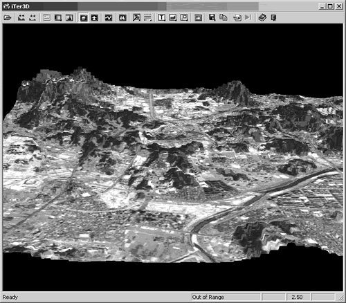 |
| Figure
3. 3D topographic visualization with image drop on a
DEM. |
Map Generation
The iMapper module of Earth 2.0 is the tool for map composition
and output. The iMapper tool is accessible directly from the
Visual Analyzer window or from the Earth Main menu. The object-based
WYSIWYG (what-you-see-is-what-you-get) interface is intuitive
and efficient for rapid image map production and customization.
The iMapper allows easy placement of the image map and a single
properties interface for specification of scale, display resolution,
draw order of pixel and vector data (if present), and coordinate
range of output. In the iMapper icon bar, tools for the map
grid (graticule), scale bar, legend, north arrow, color bar,
and other images (e.g., inset or multiple image maps in a composition.)
The grid/graticule tool is exceptionally easy to use and includes
tabs for displaying grid, latitude/longitude, and pixel row/column
coordinate locations. Annotation tools include text and text
boxes and vector drawing tools. Six north arrow styles are
included in the interface. Legend fills include solid and patterned
textures and customizable descriptions. The color bar tool
is a convenience for depicting the ranges and adding text descriptions
for continuous image variables (e.g., reflectance, elevation,
bathymetry, or NDVI.) Figure 4 shows a sample image map composed
in iMapper for Norfolk, Virginia, USA using a Landsat-7 ETM+
image (bands 5,4,3 RGB.) The iMapper module includes several
different alignment options, a print preview, and tile processor
for large maps. Maps can be exported to JPG, TIFF, and BMP
at resolutions from 72dpi to 1200dpi.
|
| Figure
4. Sample image map of a Landsat ETM+ subset of Norfolk,
Virginia, composed in Earth 2.0 iMapper map generation
module. |
Performance and Operability The software was installed on two
platforms running Windows 2000 sp2, a Dell Performance 300 desktop
PC with 1700 Mhz Pentium IV and 1GB RAM and a Gateway 9500 laptop
with 1400Mhz Pentium IV and 256MB RAM. In both cases, the software
performed at a high level. Pixoneer Corp. provided the software
and associated help files, tutorial, and sample data on cd-rom.
In addition, the software was downloaded and installed for evaluation
on the laptop PC from Pixoneer�s website for the 30-day free
trial (http://www.pixoneer.com/). The speed of image display,
zooming, and panning were excellent. The Visual Analyzer window
is ergonomically efficient, since all the tools have buttons
on the provided icon bar. In addition, the option of showing
the layers schematic and a magnification/roaming window in the
left sides of this viewer were helpful to have in the same window,
reducing the amount of desktop windows open and the necessity
of switching between open windows. Image header documentation
was provided in virtually every dialog box at the file input
section under an “info” button. Among other features,
many functions support runtime reservation, a form of batch mode
operation, in which the user can specify the time to run CPU-
or memory-intensive operations. In addition, a progress bar is
programmed in most dialog boxes to report progress when running
a task. The bar is embedded in the window of operation, making
it a useful gauge of progress since the parameters of operation
are visible while running.
With its comprehensive assemblage of image processing tools,
Earth 2.0 has few drawbacks to note. Among the few kinds of functionality
to note as lacking are the limited raster GIS analytical functions
and lack of a log file capability. Rescaling image data is not
an obvious utility on the menu system, but this task can be accomplished
by saving changes to color table transformations. Raster spatial
analysis limitations can be overcome by installation of a comprehensive
grid-based GIS package or module (Earth 2.0 readily imports and
exports ArcView format grids). Image rescale functionality, such
as changing ranges of data values by statistical or min/max parameters
would be a useful addition to future versions for scientific
and highly technical applications. Version 2.0 does include a
tool for changing the data type (e.g., # bits per pixel, signed/un-signed),
but not the range of data within these type constraints. Complex
image analysis projects involving major data conversion and management
operations could also be better managed with an additional tool
to record operations, metadata, or tracking lineage. The metadata
and lineage information can manually be added to derived data,
but a log record would be useful for large production tasks.
A convenient coordinate conversion tool (or calculator) is provided
as a “Tools and Utilities” function. While this tool
converts between many projections, coordinate systems, and datums,
it only works with points, text, and DXF vector files.
Scientific and high-end image processing users
have but a few tradeoffs to consider with the
Earth 2.0 software. The package
does not have a visual modeling capability for complex image
and raster GIS analysis functions. Interestingly, the company
also produces and sells Data Flow Modeling (DFM) technology,
a software package with flight simulation, war game, diffusion
modeling, and virtual reality applications. This Visual IDL Programming
system, trademarked by Pixoneer’s parent company (Intersys
Inc.) and marketed by Research Systems, Inc., would be a very
valuable enhancement to the Earth 2.0 software, if a convergence
or integration is not available soon. On the other hand, the
inclusion of advanced orthorectification, a neural network classifier,
and SAR/DEM tools bring the software into the high-end and scientific
realm of analysis in this version of Earth. These modules are
included in the Earth 2.0 software at no additional cost.
Product pricing for Earth 2.0 ranges from $4200 (floating server)
to $3500 (locked single use) per license for commercial users.
Military/government licenses range from $2500 to $3,000 (locked
and floating, respectively.) Educational licenses are also
offered with discounts. Multi-seat and site license prices are
available
with further discounts based on number of seats. In addition,
the purchase of software comes with technical support.
Documentation
and Tutorials
Earth 2.0 comes with online user help, tutorial,
and access to a forthcoming series of educational
modules. The tutorials walk
the user through the general analytical tools of the software.
The text is instructive in the protocols to accomplish the
tasks, providing software-specific information
progressively without
jargon. There is little redundant information from chapter
to chapter, so the completion of the tutorials
is quite a progressive,
comprehensive introduction to the software. Key dialog boxes
and sidebar explanations are provided throughout. The sample
data included with Earth 2.0 for this review included aerial
orthoimagery, KOMPSAT, LANDSAT, and SPOT satellite data imagery
and DEMs. The online help is a very straightforward reference
to the software, including a well-organized contents that mirrors
the menu and submenu system of the software. Knowledge of the
underlying algorithms is highly advised since the help contents
are very pragmatic outlines with little theoretical or underlying
data assumptions provided. References to such detail and assumptions
might be provided but are not included in the documentation.
A few cautionary notes about implicit assumptions and data
are noted in the tutorial and could be added
to future versions of
the online help. This information is also a prime candidate
for the company’s ongoing education module development. Presumably,
these forthcoming educational modules will greatly bridge this
gap for the novice user. Pixoneer informed this reviewer of work
in progress on an additional Reference Manual with technical
descriptions and underlying theory/algorithms to be provided
online with the available tutorial and help files.
Technical
Support
Technical support is offered free for one year with purchase
of a software license. This includes free upgrades of software,
on-line and toll-free telephone support (9:00-5:00 EST), online
FAQs, the PDF tutorials, and net-training via the Pixoneer
website. Pixoneer offers separate, fee-based workshops for
intensive training
in Earth 2.0, including a Basic and Advanced course in Earth
software as well as general introductory workshops on Geomatics,
and Basics of Remote Sensing to suit user needs. During this
review, technical support was promptly provided for general
questions during the installation and review, both by telephone
and e-mail.
Installation
An installation manual comes with the software, which is available
on cd-rom or via Internet download. The software easily installs
in any user-specified program filespace and requires moderate
storage (~700MB installed complete with software, data, and
tutorials.) License registration is handled by a single file
or installable
license manager for floating licenses. The single seat installed
for this review was easily updated with a new license file
after the 30-day demo period had expired. The software does
not include
an uninstall function, presumably relying upon the operating
system to remove the program from the registry.
Recommendations
Pixoneer is offering a free 30-day demo of Earth 2.0 to users.
Based on the functionality, short learning curve, and overall
ease of use, Earth 2.0 will merit the attention of many remote
sensing users, particularly those seeking a powerful, easy-to-use,
and relatively affordable image processing and classification
system to augment GIS applications. Ease of use and ergonomic
design are commendable with this software. The icons have intuitive
pictographs for their respective operations, but more important,
the arrangement of buttons on the individual viewers and submenus
makes it easy to navigate the software from step-to-step through
image analysis. The help is accessible from the main menu but
also is available in most analysis menus and dialog boxes in
context-sensitive format.
Earth 2.0 can be downloaded from Pixoneer’s website for
trial use. In addition, the company is developing educational
modules that will be an attractive accompanying item for educators
and professionals seeking to expand their use of remote sensing.
Some of the high-end functionality of Earth 2.0 (orthorectification,
SAR analysis, DEM generation, and neural network classification)
will be welcome to users previously unable to afford or access
these levels of processing typically requiring optional modules
or other specialized software.
Reviewed by:
Thomas R. Allen
Dept. of Political Science and Geography
Old Dominion University
Norfolk, Virginia 23529-0088
Tallen@odu.edu
|

