536
July 2015
PHOTOGRAMMETRIC ENGINEERING & REMOTE SENSING
Remote sensing data is used for
Biomass and Carbon Cycle
Modeling
at various scales. Monitoring vegetation dynamics and
carbon cycles is effective from landscapes to regional scales.
Ocean color radiometry explores the relationships between the
marine ecosystem, biogeochemical cycles, and climate change
at regional to global scales. The estimation of leaf area index,
probably the most complex land surface parameter, cannot be
considered operational yet for its use in any type of modeling.
LiDAR has tremendous potential in biomass mapping without
triangle, it analyzes
and looks for where
the triangle face is
most perpendicular
to a given image and
collects those pixels
into a corresponding
texture map location,
based on fit.
When the process
is finished, we end
up with a 3D surface
of the Earth and new
images, the texture
maps, which map
bits and pieces of the
original images to
the surface to form a
seamless 3D image of
Earth’s surface.
Of course there
are lots of issues
to
consider.
The
primary one being that if you don’t have stereo imagery for
a particular point on the Earth’s surface, you cannot hope to
derive that point’s structure or color. The geometry and color
of that unseen point may only be approximated based on its
surroundings.
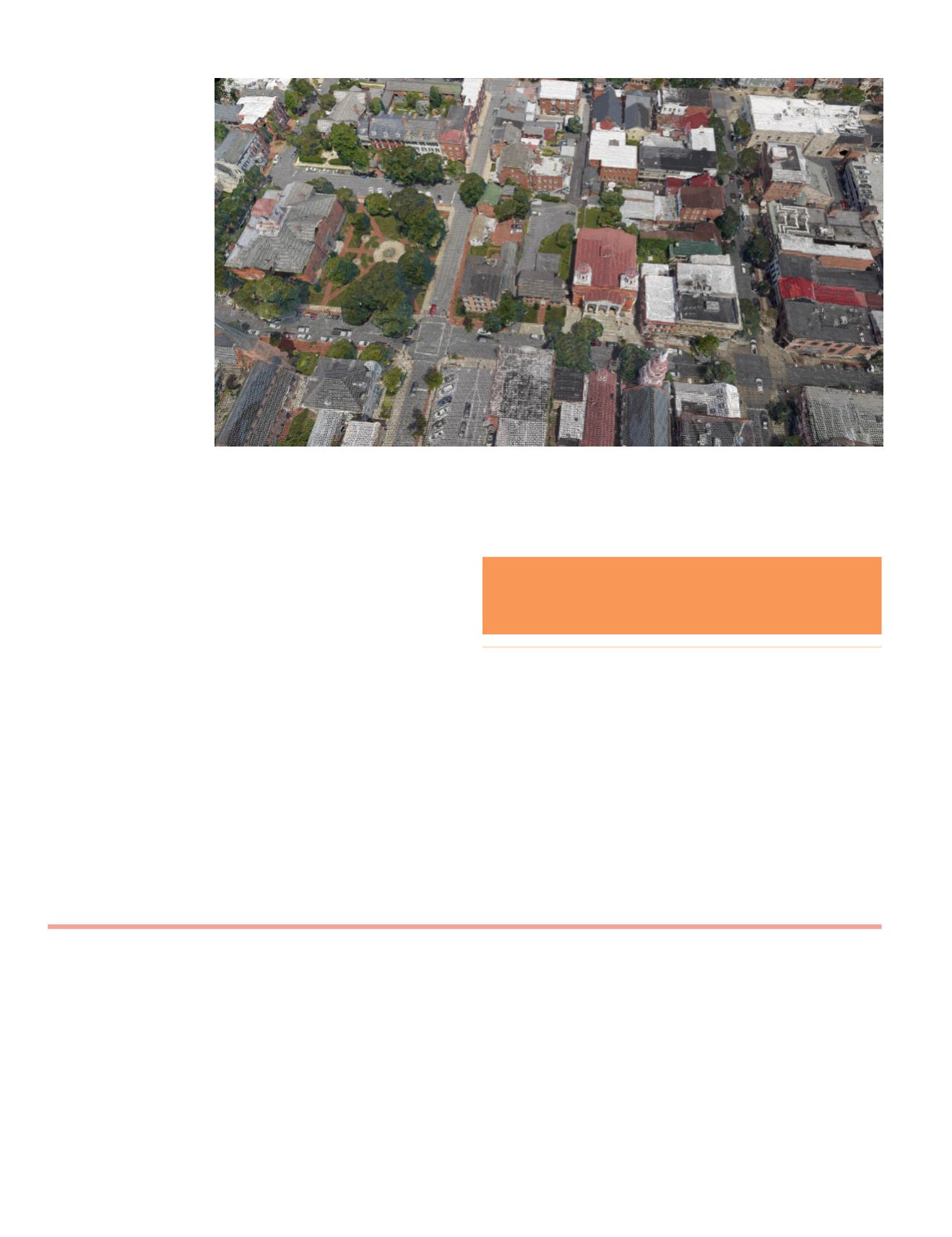
However, in practice we now are able to reconstruct
detailed skinned and textured models of the Earth’s surface
such as those shown in figure 2. The reconstructed surfaces
can be directly related back to the images that were used to
produce it. As such, measurements on the 3D model may be
confirmed by epipolar correspondence to the original images.
This provides a powerful methodology for accurate and
precise measurements, using both the 3D reconstruction and
the original bundle block adjusted imagery.
This technology as you think about it is not limited to a few
use cases as described in the first paragraph. The industry
will rapidly evolve over the next few years to bring these 3D
views into the mainstream and on to your desktop.
Figure 2. 3D city view of Frederick, MD using 2cm nadir and 3cm GSD oblique imagery collected by Icaros,
Inc. This imagery is converted to a texture map and then reconstructed on to the 3D model of the city
through an automated process. The above image is a wireframe rendering of the model with texture applied.
I would love to hear ideas for future columns.
What are you curious about?
Write me at:
**Jim Peters is a Client Development Manager at Icaros, Inc.
For ASPRS, he currently serves as the Chair for the Electronic
Communications Committee.
The contents of this column reflect the views of the author,
who is responsible for the facts and accuracy of the data pre-
sented herein. The contents do not necessarily reflect the offi-
cial views or policies of the American Society for Photogram-
metry and Remote Sensing and/or Icaros, Inc.
the limitation of saturation at high biomass levels.
A number of case studies demonstrate the use of remote
sensing data for studies of
Wetlands, Soils and Minerals
. Some
of these are more complete than the others.
In summary, the book is a useful read for all identified
audiences. The mixed levels of the content matter make it more
appealing for readers to invest in specific sections of the book
that match with their interest.
Book Review


