and 10.1). This classified shapefile is the final output from
eCognition.
ρ
d
TP
TP FN
=
+
, Probability of True Postive
(1)
ρ
fa
FP
FP TN
=
+
, Probability of False Positive, where:
(2)
TP
= Road pixel detected as road
FN
= Road pixel detected as not road
FP
= Not road pixel detected as road
TN
= Not road pixel detected as not road
The performance of the algorithm varies by county for a
number of reasons. To account for the performance varia-
tions, “percent coverage” error matrices were calculated for
each county and the coverage value that performed best was
selected as an overall value. The final result of the process is a
Michigan Framework roads layer that con-
tains an attributed unpaved roads column
ready for use in the unpaved roads assess-
ment Mission Planning System.
Results and Discussion
The study area for the project includes six
counties in Southeast Michigan: Monroe,
Washtenaw, Livingston, Oakland, Macomb,
and St Clair. Topography and land use
varies from flat, open, rural agricultural
in southern Monroe County to a densely
populated, forested glacial till plain with
a significant number of lakes in parts of
Oakland and Macomb Counties. Herold
et
al
. (2003) observed that “given the three-
dimensional land surface structure, roads
are the bottom layer that can be covered or
shadowed by surrounding surfaces such as
trees, buildings or cars.”
As that “bottom layer”, roads can be
affected spectrally by the surrounding land-
scape and land uses, such as roadside trees.
The varied landscape and land use within
the study area affects the accuracy of image
processing results.
The length of road centerline each
county road commission is responsible
to maintain varies widely i.e., from 2,803
kilometers in Monroe County to 5,861
kilometers in Oakland County. The “per-
cent coverage” value used to determine
whether a road is paved or unpaved varies
from county to county in part as a result of
the varied topography and land cover. In
Michigan, roads within incorporated areas
are not the responsibility of the county
road commissions and are excluded from
the analysis. Monroe County has the most
extensive Pavement Surface Evaluation
and Rating (
PASER
) dataset in the study area
shared by
SEMCOG
, which allowed the team
to evaluate the classification results against
a ground reference data set. The
PASER
dataset for Monroe County contains data on
2,665.4 kilometers of the 3,177.3 kilometers
of roads in the Monroe County Frame-
work Roads data layer. Monroe County
PASER
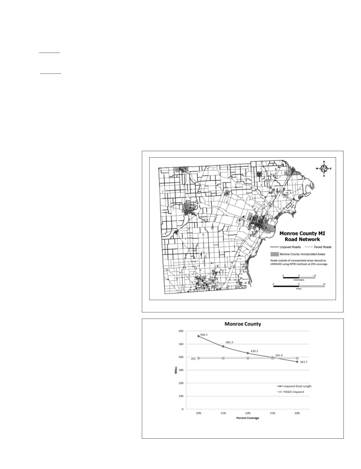
data report 629 kilometers of unpaved roads (gravel
or unimproved) out of a total county road network length
(which excludes roads within incorporated areas) of 2,803.2
kilometers (Figure 6). When road segments with at least 25
percent coverage (based on the segmentation and classifica-
tion analysis) were defined as unpaved, the
MTRI
algorithms
found 620.6 kilometers of unpaved roads in Monroe County.
The difference of approximately nine miles of roads between
the Monroe County
PASER
dataset and the algorithm’s output
indicates that the algorithm is performing well (Figure 7).
However, there were still issues of spatial agreement between
the two datasets.
When the
PASER
data were superimposed over unpaved
road classification results, it appeared that errors of commis-
sion (where the algorithm classified roads as unpaved when
the
PASER
data did not) occurred most frequently where the
road segments were relatively short and in residential areas.
A review of classification results for roads that were classified
as unpaved, but are actually paved, show that the IR-Green
Figure 7. Agreement between PASER data and the “percent coverage” used to
label a framework road segment as unpaved for Monroe County.
Figure 6. Unpaved roads in Monroe County, MI as classified by the MTRI algorithm.
PHOTOGRAMMETRIC ENGINEERING & REMOTE SENSING
May 2017
381


