Results and Discussion
General Comments
IAR
, and
FAR
calibration methods produce accurate signatures
of
VIS
classes. Signatures extracted from
EO-1
-Hyperion im-
ages (with 10 nm spectral resolution) using these methods
are sufficient to differentiate
VIS
classes at different levels.
Preliminary results using image derived signatures show
very good classification accuracy for
VIS
classes (~90 percent
overall accuracy for both
IAR
and
FAR
). Broad level
VIS
classes
are separable spectrally whereas some of the subclasses show
similar signatures. Road cement concrete and bitumen con-
crete show very similar signatures with flat reflectance values
without any diagnostic absorption. Concrete show higher
reflectance values than that from the bitumen road. Though
the soil covered bright spots (e.g., play grounds) in the image
have different spectral shape, they are at times confused with
built-up classes. Spectral matching technique such as NS
3
(Ni-
damanuri
et al
., 2011) that take into account reflectance infor-
mation as well would be helpful in such a scenario. Accuracy
of classification is largely determined by the test region than
reference region: as an average of all the pixels is taken as a
reference, whereas each individual pixel similarity is calcu-
lated in classification process (Tables 3 through 7). Figures 3
and 4 show extracted signatures of some candidate flat fields
and some sample references for soil vegetation, respectively.
Discriminating potential of the extracted signatures can be
confirmed by visual inspection.
Calibration Performance for IAR and FAR
We compared the
IAR
and
FAR
results and analyzed perfor-
mance of each calibration method for various urban land use
and land cover classes at broader level. We provide detailed
discussion in sub-sections below:
Effect of Mixed Signature as a Reference
Reference signatures from pure pixels provide more accurate re-
sults (Baseline experiments 1 and 2). There is jump of ~6 percent
in accuracy for
IAR
and for all the flat fields considered, when
concrete signature is used to identify residential area dominated
by concrete roof tops (Table 3). Furthermore, if the reference
signature is taken from large area representing mixture signature
of pure or mixed pixels, accuracy is not affected significantly
(baseline experiments 1 and 2 for both the test regions). Pro-
ducer’s accuracy is also very high for impervious surfaces (above
90 percent) except cases where two bright signatures, namely
stone quarry and concrete, are considered as references at the
same time. Irrespective of high Producer’s accuracy for stone
quarry area (~100 percent), User’s accuracy of 63-65 percent is
achieved, respectively (Experiment 6). Similar confusion occurs
when a large test region for soil contains some bright spots in it;
they are confused with bright signatures of concrete.
Vegetation Subclasses
Considering subclasses of vegetation, impervious surfaces,
and soil did not affect the accuracy by large margin. Results
showed very high overall accuracy with high User’s and Pro-
ducer’s accuracy with occasional dips for vegetation and soil
classes. Vegetation class confusion arises when a thematic class
(rather than material class) such as upmarket residential zone
is considered, which is mixture of concrete and tree pixels.
Confusion between soil and impervious surface arises when
bright pixels of stone quarry are added in reference signatures.
Some of the bright pixels in the residential area comprising
concrete roof tops are misclassified as stone quarry area.
Intra-class confusion is maximum for trees and resulted in
poor Producer’s and User’s accuracy for the class. Water hya-
cinth is identified accurately with good User’s and Producer’s
accuracy of 0.82 and 0.89, respectively (for
FAR
). Only two sub
classes are considered at present: Trees and Water hyacinth (Ex-
periment 8, Tables 4 and 5). Further investigation is required
for other vegetation classes such as green grass subtypes.
Vegetation class is generally not confused with soil or imper-
vious surface class. In case of large test region (for upmarket
residential class) which is composed of concrete roof tops and
tree covers, some of the true (possibly) tree pixels are labeled
correctly affecting User’s accuracy for tree class (Experiment 5).
Although Producer’s accuracy is lowered for a thematic class
(upmarket residential), at the material level, these results are
still true to reality, as the test area has a lot of tree cover.
Impervious Surface Subclasses
Among the two impervious material classes considered,
industrial roofs and residential roofs (concrete), there is little
intra-class confusion. Industrial roofs are identified with high
User’s and Producer’s accuracy all the time (Experiment 3, 4, 5,
7, and 8). Adding reference spectra of subclasses of vegetation
and soil does not affect accuracy of industrial roof detection
(Experiments 5, 7, and 8): the way soil classes often affect resi-
dential areas (Experiments 5, 6, and 7; Tables 4 and 5). In the
presence of bright quarry signature, residential class’s User’s
accuracy is marginally increased (by ~4-5 percent) but Pro-
ducer’s accuracy is decreased by large margin (57 percent to 53
percent) for
IAR
and
FAR
, respectively, because of the mislabel-
ing of concrete as quarry (Experiment 5 and 6: Tables 4 and 5).
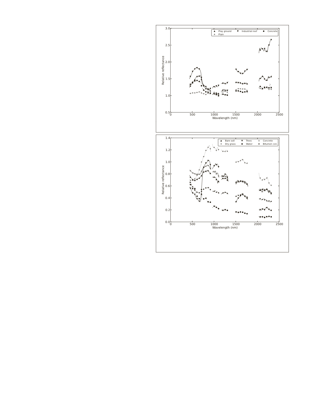
Figure 3. Signatures of the candidate Flat Fields in the
study area.
Figure 4. Sample reference signatures extracted from image.
The similarity of the pixel spectrum is compared with these
reference signatures and the pixel is given the label same as
the closest match (Algorithm 1).
372
May 2017
PHOTOGRAMMETRIC ENGINEERING & REMOTE SENSING


