a. Keeping the
EO
elements obtained in the inner
calibration process unchanged, the
GNSS
lever arms
and
IMU
boresight misalignment calibrations are imple-
mented on each orientation fix according to the sixth
and seventh equations in model (17). After calibration,
the
GNSS
lever arms (
Δ
u
,
Δ
v
,
Δ
w
) and
IMU
boresight
misalignments (
Δ
e
x
,
Δ
e
y
,
Δ
e
z
) are obtained.
b. Next, the
EO
elements are updated using the
GNSS
lever arms and
IMU
boresight misalignment calibration
values (
Δ
u
,
Δ
v
,
Δ
w
) and (
Δ
e
x
,
Δ
e
y
,
Δ
e
z
). The updating
models are as follows:
X
Y
Z
X
Y
Z
R
u
v
w
S
S
S
A
A
A
=
- ⋅
(18)
R
c
m
(
ω
,
φ
,
κ
) =
R
b
m
(
α
,
β
,
γ
) ·
R
b
(
e
,
e
,
e
)
(19)
5. Based on the updated
EO
elemen
turns to step 3, and the inner cal
a new cycle. After the new inner
finished, the scheme turns to step 4.
The outer calibration process is carried out from step 3 to
step 5 until the
EO
elements (
Δ
X
s
,
Δ
Y
s
,
Δ
Z
s
,
Δ
ω
,
Δ
φ
,
Δ
κ
),
GNSS
lever arms (
Δ
u
,
Δ
v
,
Δ
w
), and
IMU
boresight misalignments
(
Δ
e
x
,
Δ
e
y
,
Δ
e
z
)
tend to be stable and the changes between two
iterations are less than the threshold.
After the iterative two-step calibration is finished, the
true
EO
element value,
GNSS
lever arm calibration value,
IMU
boresight misalignment calibration value, and
CAM
files for
forward/nadir/backward
CCD
are obtained.
Introduction on Experimental Data
Two field calibration projects were carried out for the
GFXJ
camera. The first project was carried out in the China Nation-
al Comprehensive Remote Sensing Calibration Experiment
Field, and the second project was carried out in the Hegang
area in Heilongjiang Province.
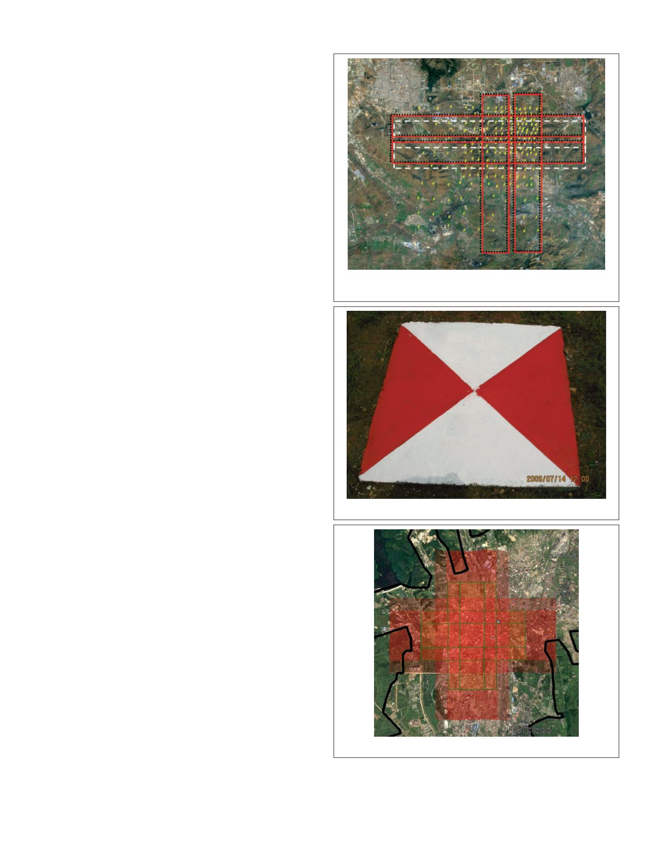
China National Comprehensive Remote Sensing Calibration Field Tests
Three blocks were flown over the China National Compre-
hensive Remote Sensing Calibration Experiment Field at 2000
m height. The test field is located in Songshan, Dengfeng,
Henan Province, China (Zhang 2012). The landform types
in the area are comprehensive, covering plains, hilly areas,
mountains, etc. The altitude varies between 100–1500 m. The
experimental field includes three parts: the aerial calibration
experiment field, the photogrammetry and remote sensing
comprehensive experiment field, and the aerospace calibra-
tion experiment field. The aerial calibration field is mainly
used for various aerial or satellite sensor calibrations, with an
area of approximately 8 km × 8 km. There are 214
GCPs
laid in
the field. Figure 7 shows the coverage of the Songshan remote
sensing field, covering the ground area of three flights and the
distribution of
GCPs
. The
GCPs
are stationary solid signals on
the ground (Figure 8), and their plane accuracy is better than
2 mm and height accuracy is better than 1 cm.
In Figure 7, the black dotted boxes show the ground cover-
age of four cross strips acquired on May 12, 2017 (hereinafter
referred to as Data A). Two strips in the east-to-west direc-
tion are bidirectional: one is from west to east, and one is
from east to west. The other two strips in the north-to-south
direction are bidirectional as well. The red solid line boxes
represent the ground coverage of four cross strips acquired
on May 23, 2017 (hereinafter referred to as Data B), and these
data basically coincide with Data A. The white broken line
boxes indicate the ground coverage of two bidirectional strips
obtained on May 25, 2017 (referred to as Data C in short).
There are 111 control points within the coverage area of Data
A, with 51 control points located in the overlapping range of
libration test field and
GCP
Figure 8. Stationary solid
GCP
.
Figure 9. Hegang test field and flight design plans.
650
September 2019
PHOTOGRAMMETRIC ENGINEERING & REMOTE SENSING


