PHOTOGRAMMETRIC ENGINEERING & REMOTE SENSING
December 2019
859
GIS
&
Tips Tricks
By Dave Maune, Ph.D., CP, GS, PS,
and
Al Karlin, Ph.D, CMS-L, GISP
Lidar Elevations for Quick Survey
Light detection and ranging (lidar) technology has been
commercially available since the early 2000’s, but has only
found its way into the mainstream of remote sensing technol-
ogies recently. Lidar collected from manned and unmanned
aerial platforms (UAVs) has put this elevation measuring
technology into the hands of scientists, GIS practitioners, as
well as traditional land surveyors. Since 2012, with the USGS
3D-Elevation Program (3DEP), millions of square miles of
high-quality, high-accuracy, lidar elevation data have been
made available to the public through the USGS National Map
(
.
Land owners in the U.S. are required to provide topo-
graphic surveys that gather data to map man-made features
and elevations of points on a parcel of land and present
them as contour lines on a plotted map document for mil-
lions of construction projects every year. These topographic
surveys differ from American Land Title Association (ALTA)
surveys, which show parcel boundaries, property improve-
ments, and easement locations. An accepted rule is that an
ALTA survey is needed when purchasing land, and a topo-
graphic survey is needed when planning construction.
With over 23,000 land survey firms in the U.S. and state
and/or regional variations guiding surveyors, topographic
surveys for construction planning may require one or more
days by a survey crew, and additional office time to process,
analyze, and produce the final topographic survey.
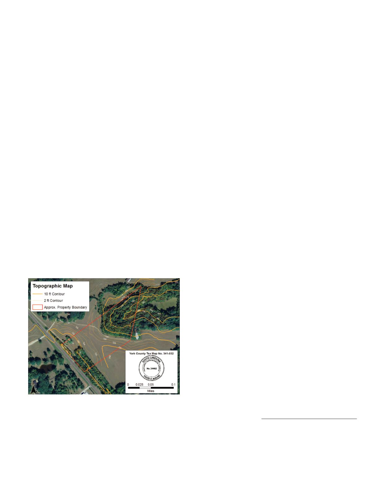
Figure 1. Topographic survey contour map produced from
lidar and other public domain data for an 8.5-acre parcel.
Figure 1 shows an 8.5-acre plot in rural South Carolina
for which a traditional topographic survey was estimated
to require six working days to acquire the data, produce the
map, and certify the survey. Alternatively, this topographic
map was produced by a Dewberry licensed surveyor using
authoritative, publicly-available lidar; ortho-imagery; parcel
boundaries; and GIS software (to produce the contours from
the lidar) at a cost of only a few hours. In this case, most
of the time was not in processing but in locating the pub-
lic-source data, and projecting it into a common coordinate
reference system.
Currently lidar data, recent ortho-imagery, and parcel
boundaries are often found on public-facing websites. Here
are some links to help get you started:
Lidar Elevations and High Resolution Ortho-imagery
•U.S. National Map (USGS 3DEP Lidar elevations):
•
/
•Digital Coast (NOAA Lidar):
-
coast/data/coastallidar.html
Parcel Boundaries (GIS-accuracy)
•Esri/ArcGIS:
?
id=4fa0b020ee4c4747be56cfbc02108716
•Data.gov:
•County Property Appraisers Websites,
ex.: ftp://public:access@ftp.hcpafl.org/shapefiles/
Most GIS and computer-aided design (CAD) software pack-
ages that can ingest lidar data from ASPRS-LAS files, such
as ArcGIS, GlobalMapper, LP360, AutoCAD, and others,
can either construct contours directly from the ASPRS-LAS
files, or may require the construction of a rasterized surface
(Digital Terrain Model, LAS dataset) as an intermediate step
prior to exporting contours into a shapefile. In any case, (1)
remember to read through the metadata so that you have a
clear understanding of the dataset, (2) make sure that you
know the coordinate reference systems (CRS), horizontal and
vertical datum, and geoid (as appropriate) of each dataset; you
may need to project/adjust data to a common reference sys-
tem, and (3) be aware of all the horizontal and vertical units
(US Feet, International Feet, Meters, etc.) to avoid “blunders.”
Whether such cost or time savings are passed on to land
owners or result in added profits for survey companies, or
whether benefits are shared, the publicly-available, author-
itative, lidar data and imagery are frequently downloaded
by land survey companies, with potential cost savings of
billions of dollars per year to the land owner.
Dave Maune, Ph.D., CP, PLS, and Al Karlin, Ph.D., CMS-L,
GISP are with Dewberry’s geospatial and technology services
group in Fairfax, Virginia and Tampa, Florida. Maune, a
senior project manager, manages all aspects of IfSAR, lidar,
photogrammetry and geodetic–related projects. As a senior
GIS professional, Karlin works with all aspects of lidar,
remote sensing, photogrammetry, and GIS-related projects.
Photogrammetric Engineering & Remote Sensing
Vol. 85, No. 12, December 2019, pp. 859.
0099-1112/19/859
© 2019 American Society for
Photogrammetry and Remote Sensing
doi: 10.14358/PERS.85.11.859


