thus cannot be assessed with most of the remote sensing data
sources. Generally speaking, input models can be impaired by
some pathological cases that are outside our evaluation frame-
work. In consequence, qualifiable models are distinguished
here from unqualifiable buildings. This first level corresponds
to a finesse equal to 0. At the finesse level 1, we predict the
correctness of all qualifiable buildings. It is the lowest seman-
tization level at which the evaluation of a model is expressed.
Then, a model is either valid or erroneous. Most state-of-the-
art evaluation methods address this level.
Model errors are grouped into three families depending on
the underlying
LoD
. The first family of errors, “Building Er-
rors,” affects the building in its entirety. It corresponds to an
accuracy evaluation at
LoD
-0 (footprint errors)
∪
LoD
-1 (height/
geometric error). At the next
LoD
-2, the family, “Facet Errors,”
gathers defects that can alter façade or roof fidelity. The last
error family, “Superstructure Errors,” describes errors that
involve superstructures modeled at
LoD
-
families are studied in this paper.
Each family contains atomic errors of
to 3. Although they can cooccur in the sa
and across different families, these errors are semantically
independent. They represent specific topological or geometric
defects. Topological errors translate inaccurate structural mod-
eling, while geometric defects raise positioning infidelity.
At evaluation time, three parameters play a role in deter-
mining which error labels to consider. The first is the evalu-
ation Level of Detail (
eLoD
). Every reconstruction method
targets a certain set of
LoDs
. In consequence, when assessing a
reconstruction, a
LoD
must be specified. At a given
eLoD
, all er-
ror families involving higher orders will be ignored. Depend-
ing on the target of the qualification process, a finesse level
might be preferred. This second evaluation parameter speci-
fies the appropriate semantic level at which errors will be
reported. The last one is error exclusivity. It conveys family
error hierarchy. Errors of a given
LoD
= 1 family are prioritized
over ones with higher
LoD
> 1.
Application to the Geospatial Overhead Case
This paper tackles the aerial reconstruction case where the
objective is to reconstruct large urban scenes using
VHR
geospatial images or, if available, Lidar point clouds. The
framework is general enough to encompass both orthorectified
images and oblique ones. In this paper, we only used ortho-
rectified images. In an ideal scenario, using oriented images
is better for edge verification (as already shown in (Michelin
et al.
2013)) as orthoimages are a byproduct of earlier ones.
However, in practice, oblique imagery would give rise to other
issues, especially, registration problems. Hereafter, 3D build-
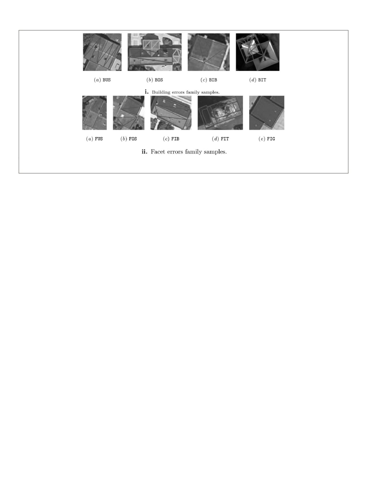
ings are evaluated. The atomic errors are (Figures 2 and 3):
Building Errors family:
• Under segmentation (
BUS
): two or more buildings are mod-
eled as one. In Figure 3.i.a, two distinct buildings were
identified as one building, even though they can be visu-
ally distinguished.
• Over-segmentation (
BOS
): one building is subdivided into
two or more buildings. This is the opposite of the previous
situation. Figure 3.i.b shows a single building that, when
modeled, was subdivided into three parts.
• Imprecise borders (
BIB
): at least one building footprint bor-
der is incorrectly located. A sample is shown in Figure 3.i.c.
y (
BIT
): the building footprint suffers
fects as missing inner courts or wrong
r instance, a circular footprint approxi-
). In Figure 3.i.d, we illustrate how the
footprint morphology can be erroneous. This error, as the
earlier ones, result either from defective building identifi-
cation process, or from an outdated cadastral map.
• Imprecise geometry (
BIG
): inaccurate building geometric esti-
mation. In case
eLoD
>
LoD
-0
∪
LoD
-1, this error is not reported
as it becomes redundant with below delineated errors.
Facet Errors family:
• Under segmentation (
FUS
): two or more facets are modeled
as one, as illustrated in Figure 3.ii.a.
• Over-segmentation (
FOS
): one facet is subdivided into two
or more facets. Refer to Figure 3.ii.b for an example.
• Imprecise borders (
FIB
): at least one facet border is incor-
rectly located. As an example, Figure 3.ii.c shows that the
central edge that links the two main roof sides does not
correspond to the one on the image position.
• Inaccurate topology (
FIT
): the facet suffers from topologi-
cal defects such as wrong primitive fitting (for example, a
dome approximated by planar polygons). In Figure 3.ii.d,
we can observe how two cylindrical towers were recon-
structed as a rectangular parallelepiped.
• Imprecise geometry (
FIG
): inaccurate facet geometric esti-
mation :e.g., wrong height or in-accurate slope. The latter
Figure 3. Illustration of various errors of our taxonomy. One can see that geometric, spectral and height information are
required for an accurate detection of all kinds of errors.
868
December 2019
PHOTOGRAMMETRIC ENGINEERING & REMOTE SENSING


