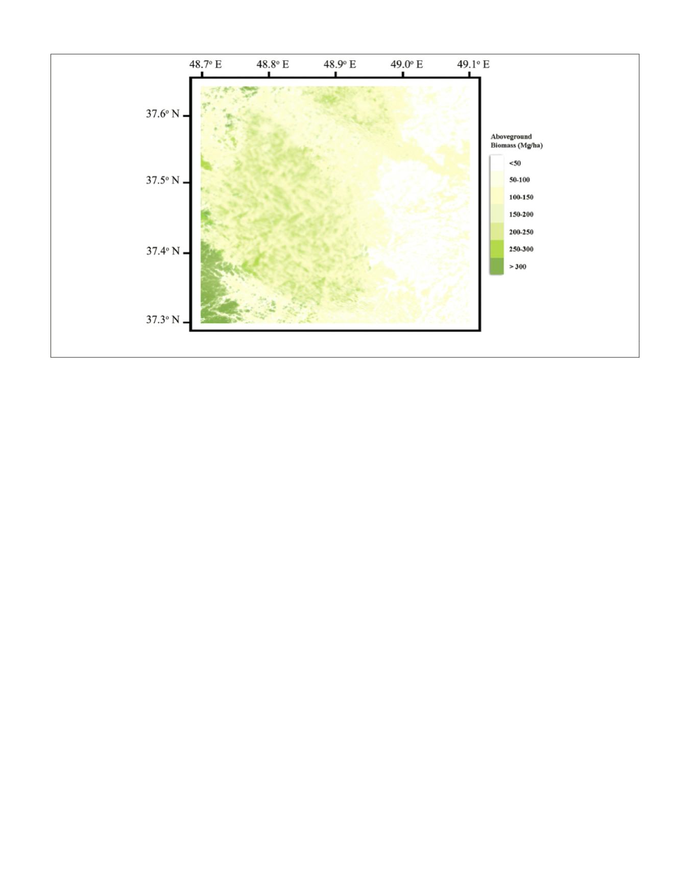
models were able to estimate the biomass of the area accu-
rately. These results show that estimation of the biomass of
dense forests (up to 300 Mg/ha) is possible using radar remote
sensing data, and such results can be used to enable manage-
ment and monitoring of wide areas of forest.
Discussion
This research compares the capabilities of
MLR
,
ANN
,
SVR
, and
MVRVR
in relation to modeling
AGB
using multi-temporal
ALOS
PALSAR
data. Forest inventories provided
AGB
reference data,
and these were used to reduce the source of the errors pre-
senting a suitable basis in the modeling process.
AGB
values of
the entire area are mostly in the medium biomass range (74 to
129 Mg/ha) in forested areas.
The results from the models were as follows. Validation
results of the
MLR
model showed that it had the lowest
R
2
and the highest errors. The saturation point of the
MLR
model
was determined at 255.66 Mg/ha, and the
ME
indicated that
the real biomass was extremely overestimated in the biomass
range between 0 and 200 Mg/ha. The
SVR
method was found
to be appropriate for use in estimating the
AGB
from multi-
temporal
SAR
data under a density of 200 Mg/ha and the satu-
ration point of
SVR
model was determined at 224.75 Mg/ha.
The limitation of the
MLPNN
model lies in the fact that it does
not reveal the mathematical relationship between the
SAR
signals and
AGB
. However, the highest saturation point, after
that of the
MVRVR
, was seen in the
MLPNN
(264.69 Mg/ha). In
contrast, the validation of the
MVRVR
model concludes that
this is the most superior method for use in calculating
AGB
.
It featured the lowest errors and highest R2 and used fewer
training data. However, the range between 0 and 150 Mg/ha
was not sufficiently represented to consider that the
MVRVR
should be selected as the best method for use in estimating
AGB
, because in this respect, the
SVR
has similar behavior.
However, the
MVRVR
was able to predict the
AGB
at higher
biomass levels, which led to a higher saturation point (297.81
Mg/ha), and this affected the error measured. Although the er-
ror values were low because of the low maximum
AGB
value;
however, in total, the real biomass is underestimated.
It is considered that the comparison of methods in this
study is extremely valuable, as most studies have only as-
sessed the use of one method, making it difficult to compare
various approaches using different data in diverse ecological
environments. However, a number of previous studies have
compared different methods to retrieve ecological parameters
from remotely sensed data. In such studies, neural network
models were found to be superior to
MLR
models according
to the results achieved (Englhart
et al.
, 2012). Other studies
have stated that the
SVR
is able to outperform neural network
models (Camps-Valls
et al.
, 2006), or that similar results can
be obtained using a regression model (Monnet
et al.
, 2011).
Such findings are comparable to those of this study, where the
neural network model outperformed the
MLR
model. How-
ever, in contrast to the results of Englhart
et al.
(2012), and in
agreement with the findings of Camps-Valls
et al.
(2006), we
found that the
SVR
out-performed the neural network model
in relation to making better
AGB
estimations, even if some of
the validation of the
SVR
model was less accurate. In agree-
ment with Englhart
et al.
, 2012, this study revealed that the
SVR
had a better performance compared to the
MLR
model.
According to these results, the
MVRVR
model has two major
advantages compared to the other models considered. For
example, it operates without the need for a large amount of
ground data, and it has a higher saturation point, which leads
to the ability to estimate larger amounts of biomass (i.e., the
biomass estimation of dense forests). The forests in Iran were
selected as the study area, as they are the most important
forests in the country and play a critical role in the carbon se-
questration of northern Iran. As such, they are key to reducing
the effects of climate change. More than half of these forests
have a high density and biomass of more than 250 Mg/ha,
which can be well-estimated using the
MVRVR
model. In addi-
tion, the estimation accuracy of this model is better than that
of the best previous method. Furthermore, the
MVRVR
model
has a higher saturation point, which enables coverage of a
wider for the estimation of biomass. Finally, use of the
MVRVR
method reduces both the time and cost involved in collecting
ground data, because it requires fewer observations. These
factors have a significant impact on enabling better and faster
Plate 2. AGB map showing the spatial distribution of estimated AGB using MVRVR in the study area
PHOTOGRAMMETRIC ENGINEERING & REMOTE SENSING
January 2016
47


