Emelyanova, I.V., T.R. MccVicar, T.G. Van Niel, L.T. Li, and A.I.J.M.
van Dijk, 2013. Assessing the accuracy of blending Landsat-
MODIS surface reflectances in two landscapes with contrasting
spatial and temporal dynamics: A framework for algorithm
selection,
Remote Sensing of Environment
,133:193–209.
Gao, F., J. Masek, M. Schwaller, and F. Hall, 2006. On the blending
of the Landsat and MODIS surface reflectance: Predicting daily
Landsat surface reflectance,
IEEE Transactions on Geoscience
and Remote Sensing,
44:2207–2218.
Gevaert, C.M., and F.J. Garcia-Haro, 2015. A comparison of STARFM
and an unmixing-based algorithm for Landsat and MODIS data
fusion,
Remote Sensing of Environment
,
156:34–44.
Hilker, T., M.A. Wulder, N.C. Coops, J. Linke, G. McDermid, J.G.
Masek, F. Gao, and J.C. White, 2009. A new data fusion model
for high spatial-and temporal-resolution mapping of forest
disturbance based on Landsat and MODIS,
Remote Sensing of
Environment
,
113:1613–1627.
Huang, B., and H. Song, 2012. Spatiotemporal reflectance fusion via
sparse representation,
IEEE Transactions on Geoscience and
Remote Sensing
, 50(10):3707–3716.
Jarihani, A., T. McVicar, T. Van Niel, I. Emelyanova, J. Callow, and K.
Johansen, 2014. Blending Landsat and MODIS Data to Generate
Multispectral Indices: A Comparison of “Index-then-Blend” and
“Blend-then-Index” Approaches,
Remote Sensing
,
6:9213–9238.
Kim, S.R., A.K. Prasad, H. El-Askary, W. Lee, D. Kwak, S. Lee, M.
Kafatos, 2014. Application of the Savitzky-Golay filter to land
cover classification using temporal MODIS vegetation indices,
Photogrammetric Engineering & Remote Sensing
, 80(7) :675–685.
Mićić, J., J. Pečarić, and J. Perić, 2013. Refined converses of
Jensen’s inequality for operators,
Journal of Inequalities and
Applications
, 1–20.
Namba, A., 2015. MSE dominance of the positive-part shrinkage
estimator when each individual regression coefficient is
estimated,
Statistical Papers
,
56:379–390.
Rao, Y., X. Zhu, J. Chen, J. Wang, 2015. An improved method for
producing high spatial-resolution NDVI time series datasets
with multi-temporal MODIS NDVI data and Landsat TM/ETM+
images,
Remote Sensing
, 7(6):7865–7891.
Shen, M., S. Piao, S.J. Jeong, L. Zhou, Z. Zeng, P. Ciais, D. Chen, M.
Huang, C. Jin, L.Z.X. Li, Y. Li, R.B. Myneni, K. Yang, G. Zhang,
Y. Zhang, and T. Yao, 2015. Evaporative cooling over the Tibetan
Plateau induced by vegetation growth,
Proceedings of the
National Academy of Sciences
, 12(30):9299–9304.
Tian, F., Y.J. Wang, R. Fensholt, K. Wang, L. Zhang, and Y. Huang,
2013. Mapping and evaluation of NDVI trends from synthetic
time series obtained by blending Landsat and MODIS data
around a coalfield on the Loess Plateau,
Remote Sensing,
5:4255–4279.
Walker, J.J., K.M. de Beurs, R.H. Wynne, and F. Gao, 2012. Evaluation
of Landsat and MODIS data fusion products for analysis of
dryland forest phenology,
Remote Sensing of Environment
,
117:381–393.
Wardlow, B.D., S.L. Egbert, J.H. Kastens, 2007. Analysis of time-series
MODIS 250 m vegetation index data for crop classification in
the US Central Great Plains,
Remote Sensing of Environment
,
108(3):290–310.
Wu, M., Z. Niu, C. Wang, C. Wu, and L. Wang, 2012. Use of MODIS
and Landsat time series data to generate high-resolution
temporal synthetic Landsat data using a spatial and temporal
reflectance fusion model,
Journal of Applied Remote Sensing
,
6:063507-063501-063507-063513.
Zhang, X., M.A. Friedl, C.B. Schaaf, A.H. Strahler, J.C. Hodges, F. Gao,
B.C. Reed, and A. Huete, 2003. Monitoring vegetation phenology
using MODIS,
Remote Sensing of Environment
, 84:471–475.
Zhang, G., Y. Zhang, J. Dong, and X. Xiao, 2013. Green-up dates in the
Tibetan Plateau have continuously advanced from 1982 to 2011,
Proceedings of the National Academy of Science
s, 110(11):4309–
4314.
Zhong, L., P. Gong, and G.S. Biging, 2012. Phenology-based crop
classification algorithm and its implications on agricultural
water use assessments in California’s Central Valley.
Photogrammetric Engineering & Remote Sensing
, 78(8):799–813.
Zhu, X., J. Chen, F. Gao, X. Chen, and J.G. Masek, 2010. An
enhanced spatial and temporal adaptive reflectance fusion
model for complex heterogeneous regions,
Remote Sensing of
Environment
, 114:2610–2623.
Zhu, X., E. Helmer, D. Liu, J. Chen, F. Gao, and M. Lefsky, 2016. A
flexible spatiotemporal method for fusing satellite images with
different resolution,
Remote Sensing of Environment
, 172:165–
155.
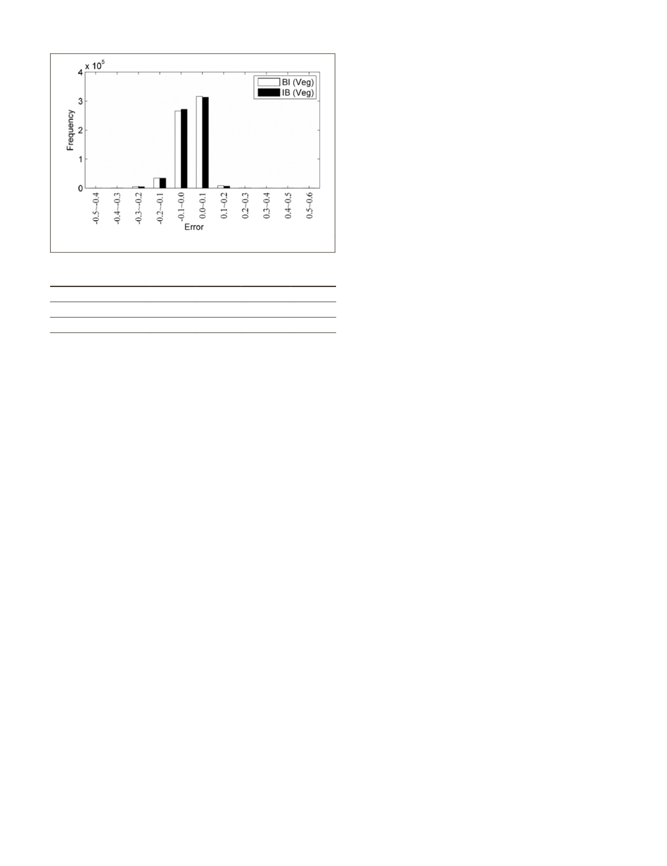
Figure 10.
BI
and
IB
error histogram for the forest area.
Table 3.
RMSE
,
R
,
AD
, and
AAD
of the predicted
NDVI
values on
11 July 2001 in the forest area.
Blending Strategy RMSE
R
AD AAD
IB
0.0561 0.7139 -0.0070 0.0395
BI
0.0579 0.7044 -0.0056 0.0410
PHOTOGRAMMETRIC ENGINEERING & REMOTE SENSING
February 2018
73


