skill of the
AASG
algorithm for large-area mapping. Currently,
the
NLCD
covers the ten-year period 2001-2011 in five-year in-
crements
2
. Our updated classifications more than double this
temporal period to cover nearly the full extent of the Landsat
archive while maintaining semantically-consistent class defi-
nitions throughout the period. This new land cover history of
the Southeast will provide a longer record of land cover and
land use change in this dynamic region, which will be useful
in ecological, biogeochemical, sociodemographic, and human
health applications.
Data and Methods
Spatial and Temporal Extents
We performed five new land cover classifications in five year
increments covering the period 1986–2006 (nominal years
1986, 1991, 1996, 2001, and 2006) across the Southeast,
which we define as the area encompassed by 116 Landsat
scenes spanning a spatial extent of roughly 21°–40°N and
73°W–101°W (Figure 1). In 2011, this region consisted largely
of forest, developed land, cultivated crops, and hay/pasture,
with extensive woody and emergent herbaceous wetlands
along the Atlantic and Gulf coasts. The Southeast classifica-
tions we develop in this research are broadly consistent with
the NLCD – currently available for the years 2001 (Homer
et al.
, 2007), 2006 (Fry
et al.
, 2011), and 2011 (Homer
et al.
,
2015) – but with expanded temporal coverage back to 1986 in
five year increments. As new Landsat OLI imagery continues
to be released in the future, the procedure developed here can
be further applied for near-automated updating of land cover
over the coming years as well.
Classification With Automatic Adaptive Signature Generalization
We developed our long-term land cover history of the South-
east using Automatic Adaptive Signature Generalization
(
AASG
; Figure 2), which allows existing land cover classifica-
tions to be extended forward or backward in time in a simple,
automated, and semantically-consistent manner (Dannenberg
et al
., 2016; Gray and Song, 2013).
AASG
identifies stable sites
between two image dates (I
1
and I
2
) using a simple image-
difference change detection method, labels these stable sites
using an existing reference classification (C
1
), and uses the
labeled stable sites to extract class spectral signatures that
are adapted to the atmospheric, radiometric, and phenologi-
cal characteristics of image I
2
(Gray and Song, 2013). These
spectral signatures are then used to produce an updated clas-
sification (C
2
) corresponding to image I
2
. This procedure thus
maintains semantic consistency in class definitions between
C
1
and C
2
, automates the classification process, and minimizes
the effects of atmospheric and phenological differences on the
signature extension process.
Using the 2011
NLCD
as the reference classification, C
1
, we
classified 1986–2006 images using the updated
AASG
proce-
dures described in Dannenberg
et al
. (2016), which, compared
to the original implementation of
AASG
(Gray and Song, 2013),
includes two methodological improvements and two updates
of the data streams. The expanded data streams, which are de-
scribed in detail in the following sections, include I
2
imagery
from multiple seasons rather than a single-date image, plus
four topographic variables derived from a 30 m digital eleva-
tion model. The methodological updates include the use of a
2. Excluding the 1992 NLCD classification, which was produced inde-
pendently of the subsequent NLCD products using different methods
and land cover classes, and is therefore not directly compatible with
or comparable to the 2001-2011 NLCD products (Fry et al., 2009).
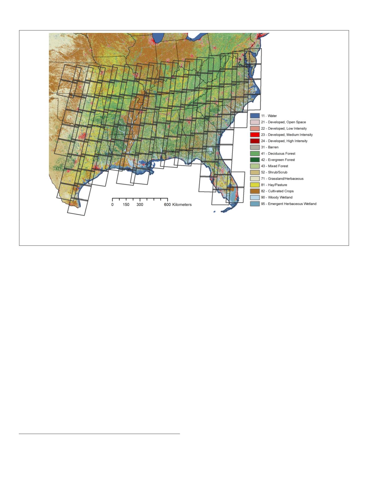
Figure 1. Study area and Landsat scenes used in this study. Boundaries of the Landsat scenes used in this study, which
include most of WRS rows 33-42 and paths 14-29, are delineated in dark gray. Background colors represent the 2011
NLCD
classification (Homer
et al
., 2015). Lists of the exact images and dates, including cloud and snow cover estimates, used in this
study are available by request.
560
September 2018
PHOTOGRAMMETRIC ENGINEERING & REMOTE SENSING


