A2. Only compensate two attitude angles. A21 represents
the
φ
and
ω
; A22 represents the
φ
and
κ
; A23 repre-
sents the
ω
and
κ
;
A3. Compensate the three attitude angles.
B. Compensate the attitude angles by one-polynomial coefficients.
Moreover, the different distributions of
ZY3-02
satellite laser
elevation control points can result in different accuracy in the
combined adjustment, which is compared and validated in
the first experimental region. The statistical results are shown
in Table 7. In the first column, the information contains the
distribution and the total number of laser elevation control
points in the combined adjustment. For instance, the 4V
means four elevation control points from
ZY3-02
satellite laser
altimetry data are used, as Figure 8a.
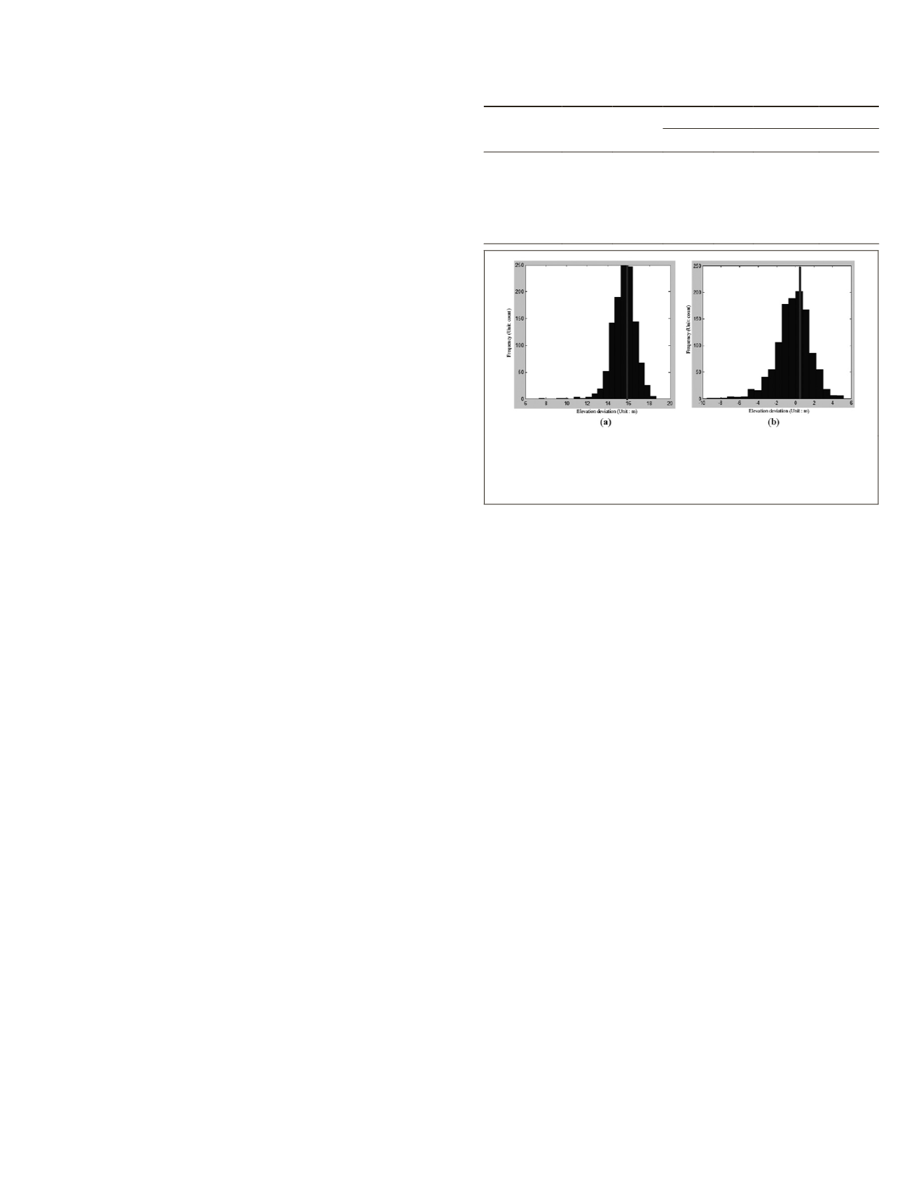
The histogram of the elevation deviation between
DSM
and
GLAS
laser reference data before and after combined adjust-
ment is shown in Figure 10.
It is clear that the new
DSM
after combined adjustment can
achieve better accuracy based on the same image-matching
method. Before the adjustment of
ZY3-02
laser elevation con-
trol and stereo images, the
DSM
exhibits a clear error deviation
compared to
GLAS
data. Moreover, the accuracy is improved
dramatically after combined adjustment, which validates the
systematic height error of
DSM
before the adjustment of the
ZY3-02
satellite laser altimetry data and stereo images. The
RMSE
of the
DSM
can be reduced to 1.866 m from 15.577 m
after combined adjustment using the laser data as the eleva-
tion control.
Discussion
In this paper, we discussed the combined adjustment of
ZY3-02
satellite laser altimetry data and stereo images for Earth obser-
vation. The
RFM
with a laser elevation constraint and the RSM
with a laser ranging constraint are implemented, compared
and discussed. Viewed as the elevation control point or rang-
ing control after selection, the
ZY3-02
satellite laser altimetry
data can improve the elevation accuracy of stereo images
without
GCPs
to better than 3.0 m. The results of
RFM
_EC and
RSM_RC are equal, although there is a small difference. When
using the RSM_RC model for the
ZY3-02
satellite, the elevation
accuracy of stereo images can be dramatically improved after
applying the laser ranging constraint and compensating angle
φ
, while the use of two other angles cannot obtain the same
result, which means the angle
φ
is the dominating elevation
error source for the stereo images. After adding some other
horizontal control points, the planimetry accuracy can also
be improved to better than 5.0 m from approximately 15.0 m.
This is the same for the integration of
GLAS
and ZY3-01 satel-
lite images (Li
et al
., 2016a), even if the
ZY3-02
satellite laser
altimeter is just an experimental version.
Moreover, we discussed the impact of different distribu-
tions of
ZY3-02
laser data in the first region. The laser eleva-
tion points located only on the four corners, on one side and
on the top, middle, bottom, and diagonal of the block were
compared and analyzed. The results suggest that the laser
elevation points should locate on the four corners and along
the track as much as possible, and locating on only one side
is discouraged. Moreover, the combination of
GLAS
and
ZY3-02
laser data was also compared. In the fourth region, the result
using only
ZY3-02
SLA
points is in accordance with that using
only
GLAS
points, and the accuracy shows a slight improve-
ment in the elevation direction after combining both of
ZY3-02
SLA
and
GLAS
data.
In order to validate the accuracy of integration, the ac-
curacy of
DSM
derived from the stereo images before and after
combined adjustment was compared. In this experiment, the
elevation results of
DSM
can improve from 15.577 m to 1.866
m according to the
GLAS
reference data, which is equal to the
checkpoints after adjustment in the third region.
Conclusions
China’s
ZY3-02
satellite is the first Earth-observing satellite
loaded with a laser altimeter and stereo cameras on the same
platform. Integration of
ZY3-02
satellite stereo images and laser
altimetry data as elevation control for high-accuracy mapping
is attractive for global mapping without
GCPs
. In this paper,
we performed experimental investigations of the integration
of
ZY3-02
satellite laser altimetry data and optical stereo im-
ages using combined adjustment by
RFM
with laser elevation
constraint (
RFM_EC
) or
RSM
with laser ranging constraint (
RSM_
RC
). The conclusions reached were obvious that combined
adjustment only using laser data can remarkably improve the
elevation accuracy of
ZY3-02
satellite stereo images without
GCPs
, whether using the
RFM_EC
or
RSM_RC
model. Moreover,
the
RSM_RC
model with laser ranging data can improve the
accuracy of the angle
φ
and the elevation accuracy of
ZY3-02
satellite stereo images. In addition, the different distributions
of laser data can affect the elevation result, and the four cor-
ners and additional laser points along the track are suggested
for implementing the adjustment. After adjustment, the
DSM
derived from the
ZY3-02
satellite stereo images realized attrac-
tive elevation accuracies. All of the results can reach to better
than 3.0m, and therefore can meet the requirement for 1:50
000 scale mapping, and it is attractive that the
ZY3-02
satellite
laser altimeter or
GLAS
data can be used as elevation control
for the non-synchronized stereo images, which is valuable for
global mapping and developing geographic resource maps us-
ing satellite remote-sensing data without any
GCPs
.
Owing to the restrictions of the
ZY3-02
satellite laser altime-
ter, further research is required to determine how to register the
stereo images and laser footprint central point more accurately,
Table 7. Comparison of results of different distributions of
laser control points in Weinan.
Distribution
Number
of GCPs
Number
of CPs
RMS (m)
East North Planimetry Elevation
Corner: 4V 4
27 8.380 6.591 10.661 2.918
One side: 2V 2
27 11.829 7.374 13.939 5.015
Top: 2V 2
27 12.784 7.717 14.933 3.395
Middle: 2V 2
27 12.708 7.740 14.879 3.369
Bottom: 2V 2
27 13.824 7.866 15.905 3.437
Diagonal: 2V 2
27 8.135 6.471 10.395 3.258
Figure 10. Histograms of
DSM
elevation error before and
after combined adjustment of
ZY3-02
satellite laser and
stereo images: (a) before combined adjustment; and (b) after
combined adjustment.
PHOTOGRAMMETRIC ENGINEERING & REMOTE SENSING
September 2018
577


