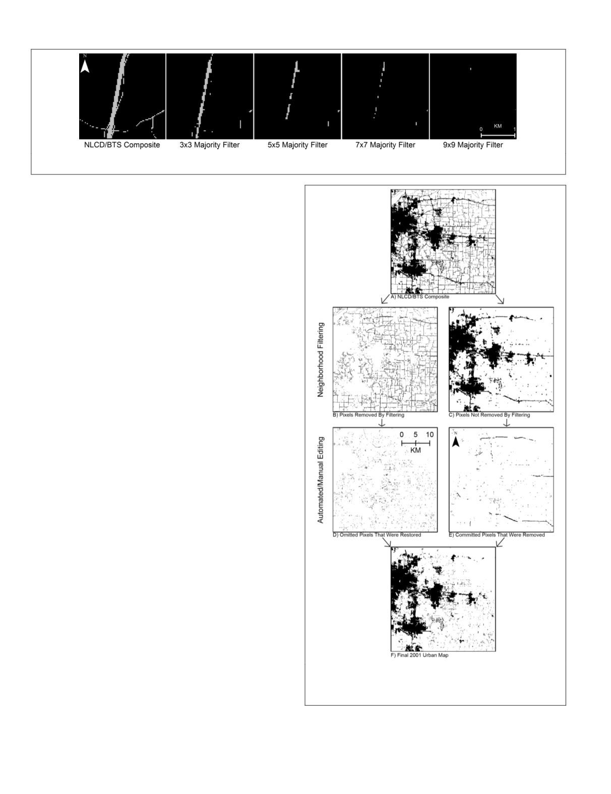
ineffective at removing wide road elements. After testing four
different kernel sizes, we settled on a 9 × 9 majority filter be-
cause it removed most road pixels without excessively eroding
core urban areas. Next, a second filter pass was applied to re-
move developed pixels remaining where roads in the
NLCD
/
BTS
composite were widest. Collectively, this process removed small
isolated pixels and thin linear features in the developed image
and left large contiguous groups of pixels intact. To restore
urban pixels omitted after the initial filtering was complete,
we performed an inverse filtering function (also referred to as
dilation) to re-insert developed pixels along the edge of urban
areas that had been nibbled away during removal of road pixels.
A qualitative assessment of the filtered
NLCD
/
BTS
composite sug-
gested that the preceding filtering steps provided an improved
delineation of urban areas, but problems remained. The filtered
product incorrectly retained groups of pixels (i.e., commission
errors) that corresponded to wide sections of primary roads,
highway interchanges, road intersections with adjacent devel-
opment, and sections of highways with parallel frontage roads.
Moreover, the filtered product incorrectly removed groups of
pixels (i.e., omission errors) where urban patches were too small
to be retained as defined by the filtering algorithm.
To improve the filtered product and to remove pixels
not considered part of the urban footprint, we performed a
clump function using ERDAS IMAGINE software (Intergraph,
2014) and deleted clumps using various criteria. The filtered
product was converted to polygon features and small clumps
with fewer than 100 pixels that did not intersect with point
features in the Geographic Names Information System (
GNIS
)
populated places (US Geological Survey, 2013) were deleted.
Larger clumps (equal to or greater than 1,250 pixels) and
clumps that corresponded to the
GNIS
database were retained
as urban areas. All clumps larger than 100 pixels but less than
1,250 pixels in size were screened using a manual editing
process. Long linear clumps designated as urban areas were
visually inspected using Google
™
Earth’s historical imagery
and manually deleted if determined to be a rural road.
Developed pixels incorrectly removed during filtering were
re-inserted into the urban footprint using a combination of
masks and manual editing steps. Pixels removed during filter-
ing that intersected with the
BTS
(US Department of Transpor-
tation Bureau of Transportation, 2016) or National Overview
Road Metrics (
NORM
) Euclidean distance (
ED
) (Watts, 2005)
datasets were considered correctly classified non-urban areas.
However, pixels that did not intersect these datasets present-
ed a challenging editing problem because they included valid
urban areas that needed to be restored, but also included areas
not considered part of the urban class, including misaligned
roads, road stubs, road shoulders, railroads, portions of fal-
low fields, drilling pads, and patches of barren. Masks were
compiled by using proximity buffers around roads, railroads,
and mining locations (Soulard
et al
., 2016; US Geological
Survey, 2016). Pixels that either fell within 90 meters of roads
and railroads or that intersected mine boundaries were clas-
sified as “not urban”. Finally, a human interpreter performed
a manual editing step to correct any remaining easily visible
errors (Figure 4).
Figure 4. Map of Kansas City, MO illustrating how
automated and manual editing processes were applied to
resolve commission and omission errors remaining after the
filtering steps.
Figure 3. Examples of different kernel filters applied to the
NLCD/BTS
composite near Butte,
MT
(45°52'55.2"N, 112°40'22.8"W)
indicates that smaller filters were insufficient in removing road pixels (gray).
104
February 2018
PHOTOGRAMMETRIC ENGINEERING & REMOTE SENSING


