rescue missions in marine environments (Sánchez-Benítez
et
al.
, 2011). Figure 6b displays the same landing platform with
the quad-rotor, from Carto
UAV
(2015) company, onboard with
an enlarged level of detail. The use of the landing platform
can be extended to different scenarios and environments.
Applications
The number of applications where
UAVs
become useful tool
seems almost unlimited and is continually growing. We have
considered different applications grouped under major topics.
Then, when appropriate, we break them down in other subtop-
ics. Obviously, this does not mean they are exclusive and surely,
other applications not covered here could be also relevant.
The European Commission (2007) identified a set of cur-
rent and potential
UAV
procurements, including: (a) govern-
ment (police, civil security, border security, coastguard);
(b) fire-fighting (forest fires, emergency rescue, other major
incidents); (c) energy sector (oil and gas industry distribution
infrastructure, electricity grids, distribution networks); (d)
agricultural forestry and fisheries (environmental monitoring,
crop dusting, optimizing use of resources); (e) earth observa-
tion and remote sensing (climate monitoring, aerial photogra-
phy, mapping and surveying, seismic events, major incident,
pollution monitoring); and (f) communications and broadcast-
ing (Very High Altitude-Long Endurance (
VHALE
) platforms as
proxy-satellites and Medium Altitude-Long Endurance (
MALE
),
or Small and Mini-Unmanned Aerial Systems (
S/MUAS
) as
short-term, local communications coverage). Nowadays,
many developments have followed these lines with success-
ful results. The overview about the current state carried out in
this paper focuses on a set of applications classified under the
specific topics displayed in Table 3 for various areas. This di-
vision is established considering the main application, taking
into account that some type of overlapping among them may
occur. Indeed, when a disaster occurs, humanitarian localiza-
tion and rescue are tasks to be executed immediately. Pho-
togrammetry (mosaics, ortho-rectification) is an application
useful with great relevance in agriculture, cultural heritage,
and archeology or urban environments, among others.
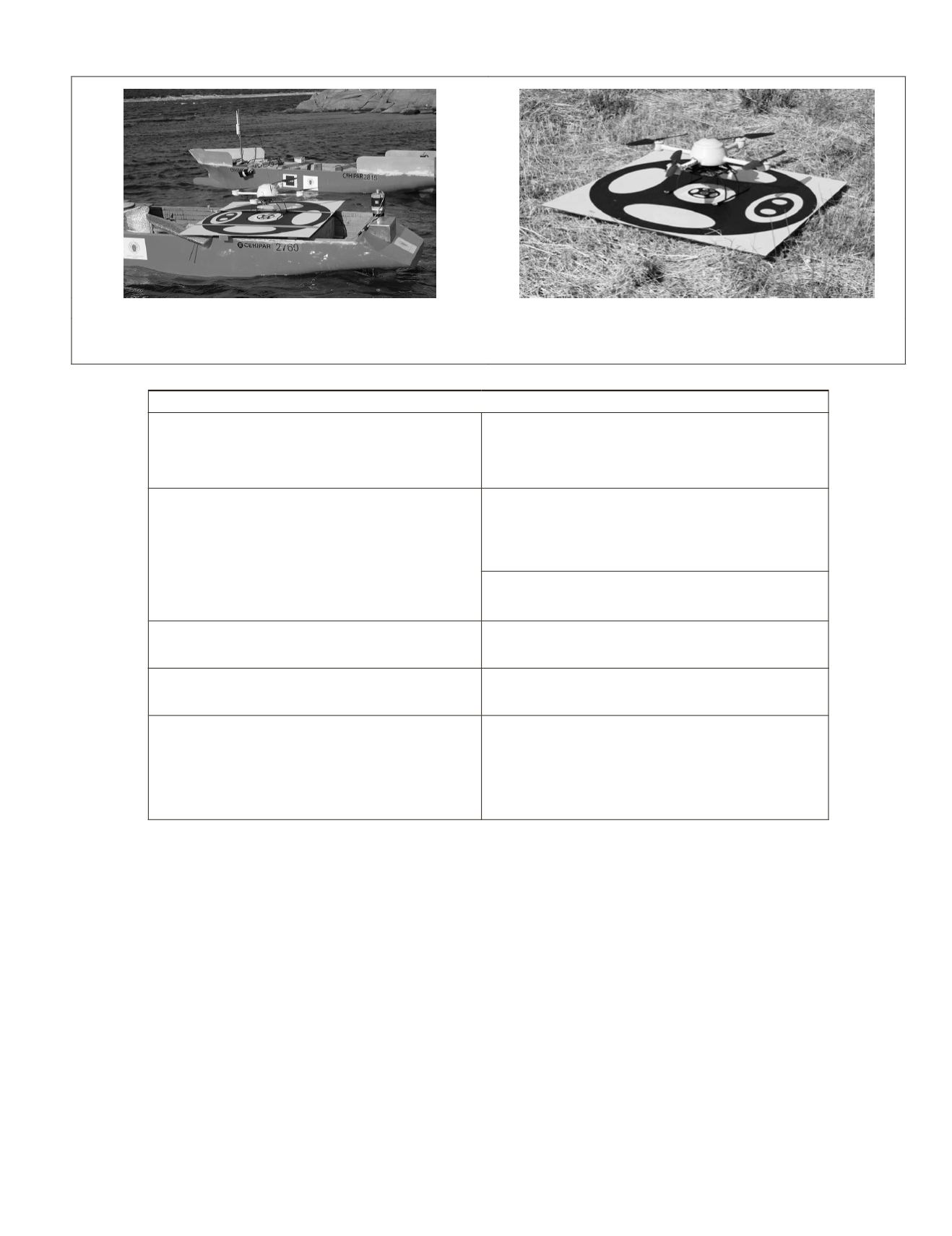
(a)
(b)
Figure 6. (a) Quad-rotor landed onboard a
usv
(boats property of Distance University of Spain,
uned
), and (b) Landing platform (Images
courtesy of ISCAR-UCM Group, University Complutense of Madrid, Madrid, Spain)
T
able
3. A
pplications
: A
reas
and
T
opics
Areas and topics
• Agriculture and forestry
• Crops and weeds
• Trees in forestry
• Forests
• Soil and others
• Vegetation
• Coverage
• Development
• Disaster monitoring
• Hurricanes, typhoons and tornados
• Earthquakes
• Fire
• Nuclear leaks
• Spills detection
• Floods
• Avalanches
• Epidemiology
• Photogrammetry
• Digital elevation models and 3D mapping
• Mosaicking, ortho and geo-rectification
• Measurements
• Cadastral applications
• Atmospheric
• Observation
• Air analysis and pollution
• Humanitarian
• Localization
• Rescue
• Cultural
• Heritage
• Archeology
• Surveillance
• Traget detection
• Tracking
• Wildlife: inventories and monitoring
• Fauna
• Flora
• Environmental monitoring
• Volcanic inspections
• Soils
• Aquatic environments
• Canopy
• Rural roads and geological infrastructures
• Urban environments
• Surveillance
• Tracking
• Road information
• Urban configuration
• Facades analyisis
• Urban terrain reconstruction
PHOTOGRAMMETRIC ENGINEERING & REMOTE SENSING
April 2015
293


