PHOTOGRAMMETRIC ENGINEERING & REMOTE SENSING
April 2018
187
ASPRS
NEWS
New ASPRS Lidar Guidelines
the aegis of the ASPRS Lidar Division and the Airborne Lidar
Committee, to recommend processes that must be followed to
assure the geometric quality of lidar data. The WG recommends
that further research and developmental efforts are necessary
to comprehensively understand the process of lidar data quality
assessment.
R
elative
accuracy
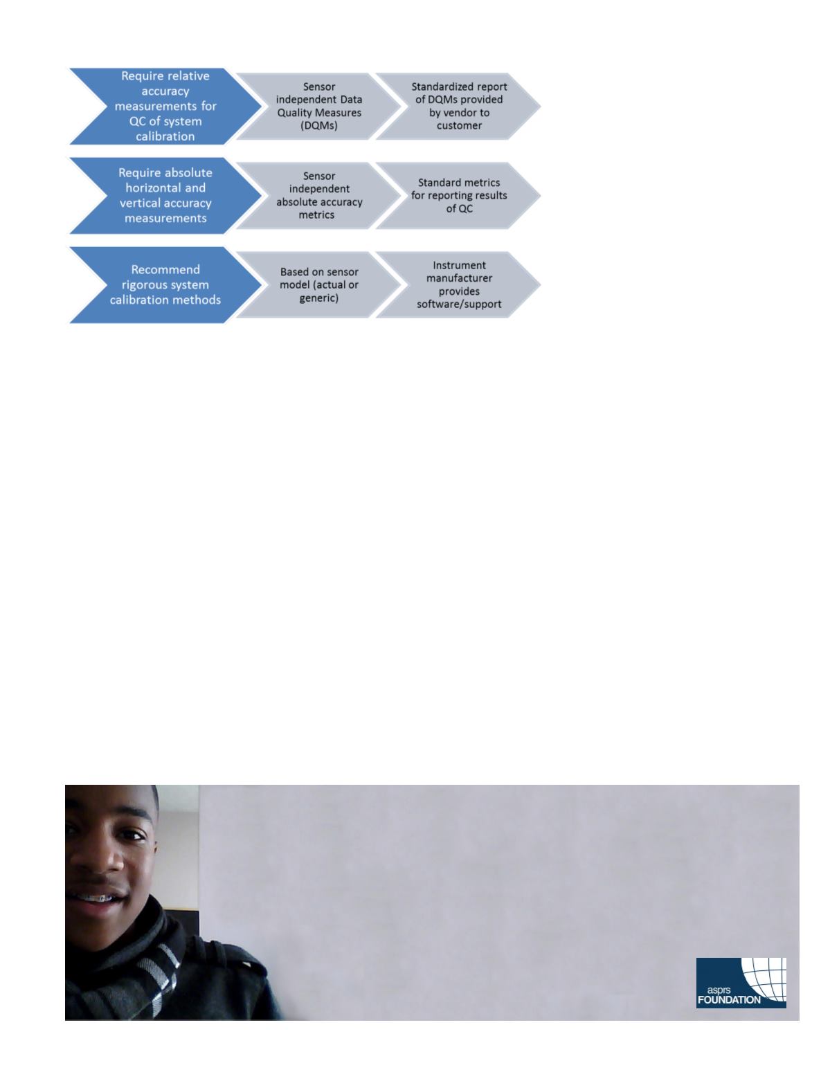
The WG recommends that quality control processes associated
with testing the quality of calibration/boresighting of lidar
instruments be developed and standardized for the industry.
The geometric quality of data, which includes the quality of
calibration, most easily manifests itself in the overlapping
regions of the various swaths of data. Therefore, procedures to
test the relative accuracy of the data, i.e. testing the accuracy
within the swaths of the data are recommended to be imple-
mented in a transparent and standardized manner. The WG
has made progress in developing metrics, which are detailed
in the “ASPRS Guidelines of Measurement of Inter Swath
Geometric Quality of Lidar data”.
Framework of recommended QA/QC guidelines
A
bsolute
accuracy
The WG recommends that research efforts
towards developing affordable absolute
accuracy measurement techniques for
assessing the three dimensional accuracy
of point clouds be made. On most occasions,
only the vertical accuracy is tested, with
the horizontal accuracy assessments
ignored due to lack of easy means of
measurements and standardized metrics.
This level of testing is adequate to assess
low resolution point cloud data meant
for generating Digital Elevation Models.
However, for 3D analytical applications,
the quality of all three dimensions of the
point cloud is essential. It is important,
therefore, to develop cost effective means of
assessing the three dimensional accuracy of lidar point clouds.
S
ensor model
based
calibration
The WG recommends that sensor calibration and data acqui-
sition follow sensor manufacturer recommended procedures
for instrument calibration and boresight angle determination
while performing data acquisition. This includes data driven
determination of optimal boresight parameters using the lidar
instrument’s sensor model. Since most of the lidar instrument
sensor models are proprietary, the WG cannot recommend any
specific methodology.
The USGS-ASPRS led WG has had success in defining and
developing Inter-Swath Data Quality Measures (DQMs) for
measuring the consistency of features found in the overlapping
regions of different swaths of lidar point cloud. The effort has
been supported by The USGS’s National Geospatial Program
(NGP) and the Land Remote Sensing (LRS) program.
Too young to drive the car? Perhaps!
But not too young to be curious about geospatial sciences.
The ASPRS Foundation was established to advance the understanding and use of spatial data for the
betterment of humankind. The Foundation provides grants, scholarships, loans and other forms of aid to
individuals or organizations pursuing knowledge of imaging and geospatial information science and
technology, and their applications across the scientific, governmental, and commercial sectors.
Support the Foundation, because when he is ready so will we.
asprsfoundation.org/donate


