We also used a two-pass
DInSAR
, in which error term compen-
sation is based on external weather information.
Time Series Analysis
Based on the limited number of
InSAR
pairs, we tested Hoop-
er’s (2008) approaches which represent interferogram time
series but which also employ complementary
PS
and
SBAS
.
Hooper
et al
. (2004) tackled the problems of conventional
DInSAR
by introducing new
PS
definition methods investigat-
ing spatial correlations of phases and extracted the confiden-
tial results over the natural landscape terrain. The algorithm
was later updated using a spatial correlation of interferogram
phases to find pixels with low-phase variance in all terrains
as shown in Hooper
et al
. (2007) and produced reliable defor-
mation over the Alcedo Volcano, Galapagos, where the vegeta-
tion extends even to the highest altitudes. Later, the algorithm
was once more improved incorporating the
PS
and
SBAS
results by applying a spatial correlation tracing method of
phases for
SBAS
interferograms (Hooper, 2008). The basic aim
of this effort was to increase the spatial sampling for updating
the resolution of deformation measurements as well as to gain
the ability to realize precise phase information by combin-
ing
PS
and
SBAS
. Measurement of
PS
pixels was conducted by
measuring the variation in residual phase (Hooper et
al. 2004) as shown below:
γ
x
x i
x i
ex i
i
N
N
exp
=
−
− −
(
)
′
=
∑
1
1
1
{
}
,
,
,
Φ Φ Φ
ˆ
(5)
Here,
N
is the number of interferograms,
Ф
x,i
is the
phase change in pixel
x
,
Ф
ˆ
x,i
is phase change in the
sample mean within window patch, and
Ф
ˆ
ex,i
is the
estimated phase change residual with window patch.
If the value is below a predefined threshold, it was
considered to be a stable scatterer.
Therefore, the
StaMPS
software implementing the
InSAR
persistent scatterer (
PS
) method and
SBAS
in
combination (Hooper, 2008) was employed to mine
PS
pixels in the target area that possess highly chal-
lenging conditions for
PS
tracing. Using the identified time
series and
PS
pixels, the displacement occurring over target
areas could be traced. Successful monitoring using
StaMPS
in
similar conditions is found in Hooper
et al
. (2007), Pinel
et al
.
(2008), Chang
et al
. (2008), and Decriem
et al
. (2010), Liu
et
al
. (2013), Tomas
et al
.(2014).
Hooper (2008) argued that a reliable deformation map
could be constructed from only 12
InSAR
interferograms, while
another case of deformation detection used only eight
ENVISAT
ASAR
images in combination with
PS
time series analysis
(Qiang
et al
. 2010). However, with such few pairs, error ef-
fects likely remain in the inversion process of time series
analysis. In response, we employed a complementary
StaMPS
approach to compare 2-pass
DInSAR
results.
Two Pass DInSAR Analysis and Error Correction
GPS
signal delay analysis, radiometers in space (Li
et al
. 2006),
a weather forecasting model (Wadge et al. 2002), and ground
observation have been used for regulating atmospheric er-
ror factors for two-pass
DInSAR
. Water vapor leading to wet
propagation delay in the electromagnetic wave is of primary
interest; however, temperature and pressure profiles induc-
ing the dry phase delay might produce comparable errors in
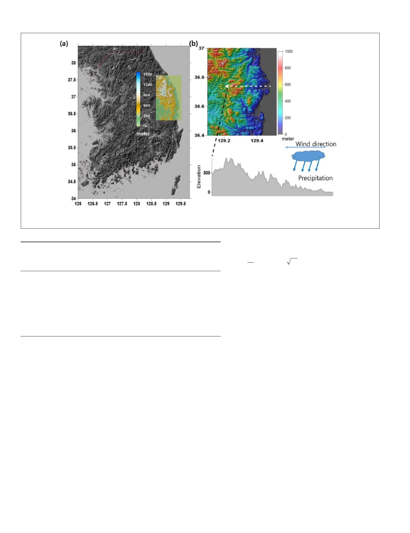
Figure 1. The location of Uljin County and
InSAR
coverage are shown in (a). Shaded relief representation of the area along
with a
EW
profile and a description of the orographic effect are displayed in (b).
Table 1.
SAR
images over target area and their characteristics.
Acquisition time
Perpendicular
baseline
(meter:master
image 2004-07-24)
Incidence
angle
(deg)
orbit Track Pass
2004-07-24 13:09
0
22.773 12546 468 Ascending
2005-01-15 13:09
-247.076
22.780 15051 468 Ascending
2005-04-30 13:09
-628.918
22.815 16554 468 Ascending
2005-11-26 13:09
578.855
22.812 19560 468 Ascending
2005-12-31 13:09
1125.753
22.849 20061 468 Ascending
2006-03-11 13:09
855.554
22.831 21063 468 Ascending
2006-04-15 13:09
-340.156
22.796 21564 468 Ascending
2007-01-20 13:09
803.392
22.827 25572 468 Ascending
192
April 2018
PHOTOGRAMMETRIC ENGINEERING & REMOTE SENSING


