The total number of images is given in
Table 2 and confirms the complementarity
between Sentinel-1 and Sentinel-2 images. On
Site77, particularly high cloud coverage led
to only 12 Sentinel-2 images. In addition, S2
orbit over Site77 had many acquisition prob-
lems in 2016. On the contrary, on this site,
ascendant S1 images overlap, leading to more
available radar images.
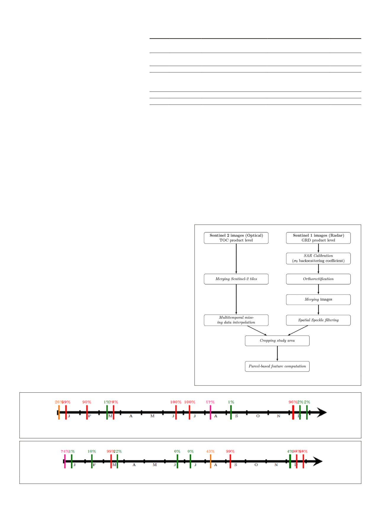
Sentinel Images Preprocessing
Figure 5 illustrates the optical and radar
preprocessing steps to obtain parcel-based
features for the classification workflow.
The dual polarization
GRD S1
images were first calibrated
to
σ
0 radar backscattering coefficient. The orthorectification
was performed using the Shuttle Radar Topography Mission
(
SRTM
) digital terrain model. The speckle is partly removed
using a simple 5 × 5 Lee filter (Lee 1980). In addition to
VV
and
VH
radar features, an extra radar feature (
σ
0
VH
/
σ
0
VV
) was
derived. This ratio is known to be more robust to acquisition
system errors or environmental factors such as soil moisture
leading to a more stable temporal indicator (Veloso, Mermoz,
Bouvet
et al.
2017). Average and standard deviation of these
three features were then computed for each date and for each
parcel. The number of radar features is shown in Table 2.
Sentinel-2 images were already orthorectified and calibrat-
ed in TOC reflectance. On Site77, only 12 Sentinel-2 optical
images were obtained in 2016, as shown in Figure 6 with
corresponding cloud cover, whereas 23 images were available
on Site04 (cf. Figure 7). The missing data (clouds) were filled
using a multi-temporal spline interpolation (Inglada 2016).
Average and standard deviation of the 10 spectral bands and
the Normalized Difference Vegetation Index (
NDVI
) per optical
image were then computed for each date and for each parcel.
The number of optical features is shown in Table 2.
Methodology
Our method proceeds in two steps: parcel-wise classification
and temporal modeling. The first step aims to predict the crop
types per parcel using Sentinel time-series for each year inde-
pendently. The second step integrates the temporal structure
into a probabilistic structured model representing the influ-
ence of crop rotations. Modeling this temporal dependency
may help correct erroneous classifications made in the first
step and may also help classify ambiguous parcels by consid-
ering crops from previous years.
Parcel-Wise Multi-Source Classification
We first compute discriminative parcel-based features from
satellite time-series. For each parcel, we consider all available
optical and radar images for one year. We consider the aver-
age and standard deviation of each spectral feature over the
pixels composing the parcel extent. We then concatenate the
observations over the span of a year of acquisitions. A Ran-
dom Forest classifier provides a parcel-wise prediction under
the form of pseudoprobabilities.
For a given parcel
i
and a given year
t
, we denote
X
i
(
t
)
∈
R
D
the tensor of combined selected features, with
D
the selected
feature size. Since we compute both mean and standard devia-
tion for each channel at each time step,
D
= 2×
C
×
S
, with
C
the
number of channels, and
S
the number of acquisitions per year.
To counterbalance the over-representation of certain classes in
our data sets, we set class weights inversely proportional to the
square root of the number of instances in each class. This class
weights are used by the random forest classifier to give more
importance to rare classes and recover them more easily.
Temporal-Structured Classification
We now consider the year-by-year temporal structure of each
parcel independently. We denote by
X
i
(
t
)
∈
R
T
×
D
the sequence
Table 2. Characteristics of the parcel-based features for both sites.
Site
No. of
dates
Optical features
Radar features
Total
04
Optical: 23 22 per image
6 per image
Optical: 460
Radar: 28
σ
,
µ
of (10 bands + NDVI) (
σ
,
µ
of 3 radar features) Radar: 168
Total
628
77
Optical: 12 22 per image
6 per image
Optical: 240
Radar: 85
σ
,
µ
of
(10 bands + NDVI)
(
σ
,
µ
of 3 radar features) Radar: 509
Total
749
Features are detailed in the text.
Figure 6. S2 optical images over the year 2016 and corresponding cloud cover on Site04.
Figure 7. S2 optical images over the year 2016 and corresponding cloud cover on Site77.
Figure 5. Sentinel-1 and -2 preprocessing steps.
434
July 2020
PHOTOGRAMMETRIC ENGINEERING & REMOTE SENSING


