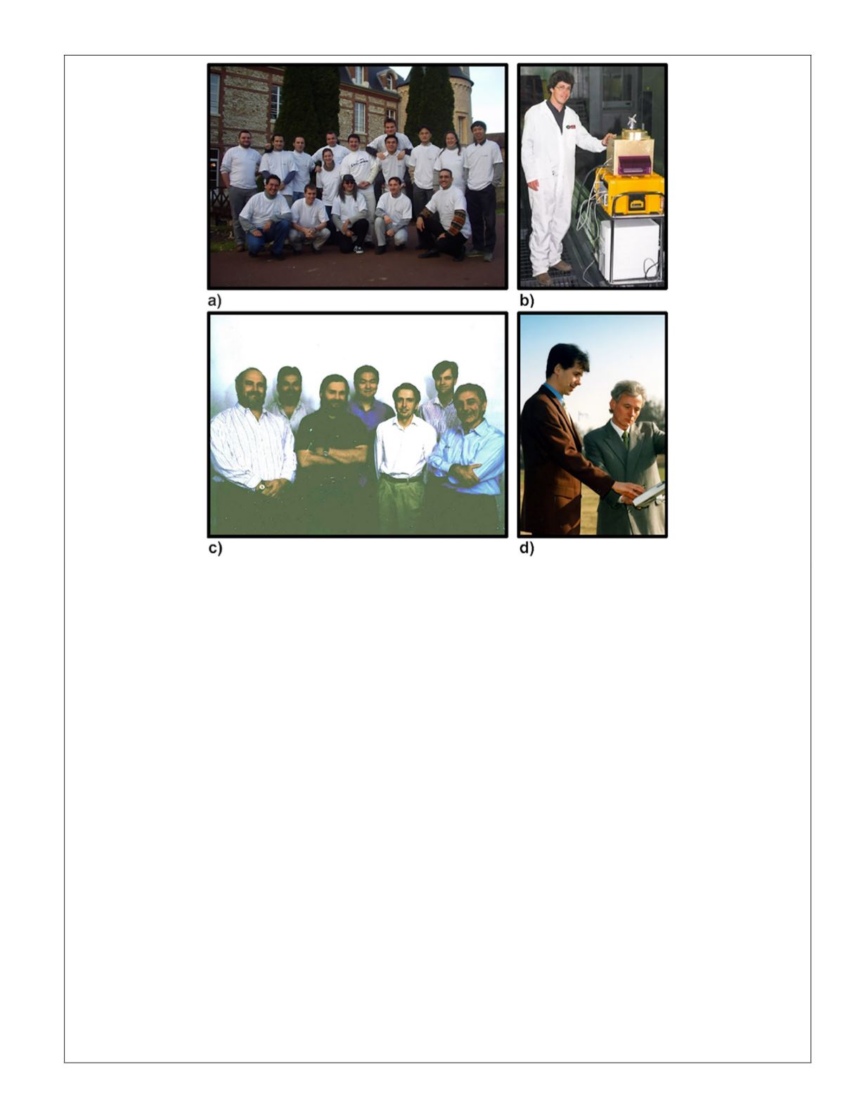
Figure 5. Key teams and some of the people who brought midrange terrestrial laser scanning (
TLS
) solutions to market in
1997–1998. I would like to thank Xin Chen for the Mensi group photograph, Markus Mettenleiter for the SceneModeler
photograph, Reigl USA for the photograph of Andreas Ullrich and Johannes Riegl, and Gregory C. Walsh and Guy Cutting for
the Cyra Technologies group photograph. (a) The Mensi development team in France, 2001. Though they would cross over to
time-of-flight scanning that same year, their work in laser-based optical triangulation (via the
SOISIC
scanner) helped to bridge
the gap between close and midrange scanning between 1987 and 2001 (this is discussed in part two of this article). Trimble
acquired Mensi in 2003. Far right, standing: Xin Chen, Chief Technology Officer of Mensi; far left, kneeling: Omar-Pierre
Soubra, who also went on to work for Trimble and then Dassault in director-level marketing roles. (b) Christoph Fröhlich,
Dirk Langer, Markus Mettenleiter, and Franz Haertl played a key role in helping to develop the K
2
T/Quantapoint Franklin and
then SceneModeler phase-shift scanners. They went on from their time at the Robotics Institute at Carnegie Mellon University
to develop the Z+F range of phase-shift scanners. Four of this German cohort of the phase-shift story graduated from the
Technical University of Munich; Haertl had been working on hardware and software development for Z+F’s preexisting wire-
processing machinery business before transitioning to the emerging midrange
TLS
side of the business. This photograph was
taken by Christoph Fröhlich and shows Markus Mettenleiter with an early version of the SceneModeler. It is seen to contain
all of the components that would go into commercial midrange
TLS
(discussed in part two of this article). The big yellow
box contains a signal processing unit. This and the computer were replaced in later versions of the SceneModeler by two
smaller blue boxes that contained smaller single and computer hardware. Leica Geosystems sold Zoller and Fröhlich laser
scanners under an original equipment manufacturers (
OEM
) agreement from 2005 to 2012. (c) Cyra Technologies was formed
by Ben Kacyra and Jerry Dimsdale in California in 1993. The photograph shows Chief Technology Officer Jerry Dimsdale
(front left), Chris Thewalt (back left), Jonathan Kung (back middle), and chief executive officer Ben Kacyra (front right).
Cyra Technologies combined a 532-nm pulsed green laser from the Massachusetts Institute of Technology Laboratory with
a timing circuit developed at Los Alamos National Laboratory to create its Cyrax scanners. The company also played a key
role in helping form a stable market around midrange
TLS
, especially after its acquisition by Leica Geosystems in late 2000.
Dimsdale, after the acquisition of his later company Voxis, went on to create another generation of midrange
TLS
systems that
became the
GLS
series of scanners for Topcon. Kacyra went on to form the cultural heritage-based nonprofit CyArk (discussed
in more detail in part two of this article). (d) Riegl is an Austrian company that brought a time-of-flight midrange
TLS
system
to market in 1997–1998. This photograph shows Andreas Ullrich (right), who went on to become Chief Technology Officer at
Riegl, next to the company’s founder and namesake, Johannes Riegl. Ullrich played a fundamental role in the development
of the system architecture for the Riegl LMS-Z160/Z210 scanners. They were developed out of an European Space Agency
funded project exploring landing shuttle sensors in the 1990s. Both Johannes Riegl and Andreas Ullrich graduated from
the Vienna University of Technology (
VUT
). Dr. Riegl carried out long terms research at
VUT
on avalanche pulse generators
(nothing to do with snow and ice) prior to forming the company in 1978. Ullrich completed a
PhD
thesis based on high-
resolution optical Doppler radar. By the time this article was published, Riegl had evolved into a company with a long history
in the development of tripod-based and simultaneous and localized mapping (
SLAM
) laser scanning systems (discussed in
more detail in part two of this article).
PHOTOGRAMMETRIC ENGINEERING & REMOTE SENSING
July 2020
425


