delimitation) and the corresponding semantic information
such as the owner, the operator, the area, and the crop type.
Both geometric and semantic information are updated by
the farmers annually. Until 2014, the declarations were made
at a block scale that corresponds to contiguous parcels with
the same operator. Since 2015, the declarations have been
made at the parcel scale, which simplifies machine-learning
based approaches to crop prediction. The crop type is speci-
fied among more than 300 subclasses which are organized
into 25 classes. 14 and 10 of these classes are present on
Site04 and Site77, respectively (cf. Table 1).
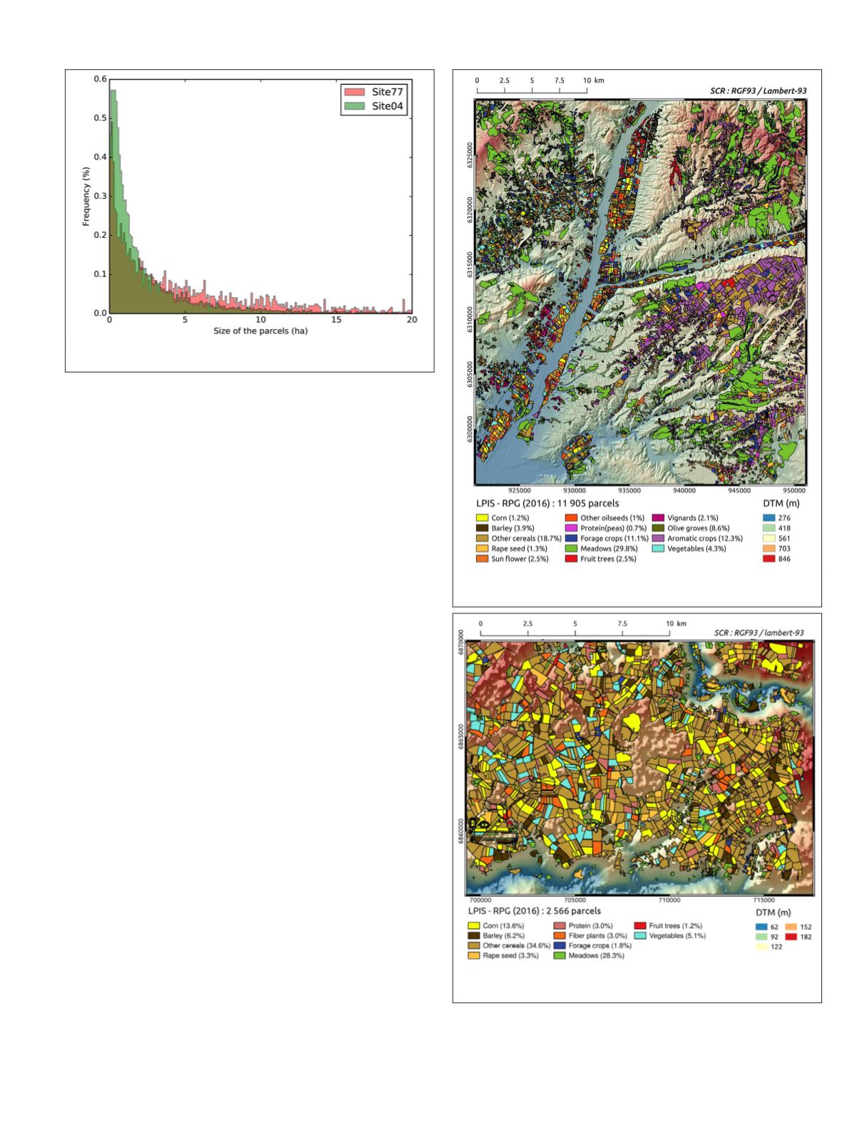
Figures 3 and 4 show the 2016
RPG
edition, i.e., the ground
truth data on Site04 and Site77 respectively, with the corre-
sponding crop types. For Site04, dominant crops are: cereals
(23.8%), meadows (30.7%), aromatic crops (12.2%), forage
crops (10.2%), and olive groves (8.6%). As for Site77, two
dominant crops are present: cereals (57.7%) and meadows
(28.3%), followed by vegetables (5.1%). In this latter case, the
data is highly imbalanced, making Site77 classification task
more complex.
In this study, to be in tune with the first Sentinel-2 images
availability, only the 2016 edition of parcel-based
RPG
was
used for the training and the validation of the supervised clas-
sification model (see the section “Parcel-Wise Multi-Source
Classification”). The 2015 parcels were necessary to train
the temporal structured method (see the section “Temporal-
Structured Classification”). For learning crop rotations, only
the geometrically stable blocks of parcels from 2010 to 2014
were used. The number of geometrically stable parcels for
both sites is given in Table 1.
Multimodal Sentinel-1 and -2 Images
We use both optical and radar Sentinel time-series for crop
mapping. Sentinel-2 (S2) provides 10 multispectral bands
for earth observation on the visible-short-wave infrared
(VIS-
SWIR
) domain at 10 m and 20 m spatial resolution. Near
infrared (
NIR
) and red-edge bands allow a fine characterization
of crops. Sentinel-1 (S1) is a C-band
SAR
. The available mode
on the studied sites was the Interferometric Wide (
IW
) mode
that presents a dual polarization
VV
and
VH
.
For the year 2016, Sentinel-2 images were automatically
downloaded from the Theia platform (
-
land.fr/) in tiled format, calibrated as Top of Canopy (
TOC
)
reflectance (Hagolle, Huc, Villa Pascual,
et al.
2010) and
accompanied with robust cloud mask information (Hagolle,
Huc, Villa Pascual,
et al.
2015). The 20 m Sentinel-2 images
were resampled to 10 m spatial resolution. Radar Sentinel-1
images were downloaded from the Peps platform (https://
peps.cnes.fr) in the Ground Range Detected format (
GRD
)
which corresponds to the average of approximately five Single
Look Complex acquisitions corrected by the incidence angle
and resampled at 10 m spatial resolution.
Figure 2. Normalized histogram of parcel areas for Site04
and Site77.
Figure 3. Site04: 2016
RPG
parcel superimposed to a very
high resolution Digital Terrain Model.
Figure 4. Site77: 2016
RPG
parcel superimposed to a
SRTM
Digital Terrain Model.
PHOTOGRAMMETRIC ENGINEERING & REMOTE SENSING
July 2020
433


