data, and an obvious example is the emergence of northeast
to southwest and northwest to southeast stripes in flat areas
(Gallant and Read, 2009; Miliaresis and Paraschou, 2005).
In Figure 6c, the distribution curve of the aspect in rolling
terrain (with slope greater than 5°) tended to be smooth. The
frequency in the main and secondary directions were signifi-
cantly reduced, and the proportion of sample points in north
and south directions were more than in the east and west
directions. These patterns were as same as those in the aspect
distribution of
Hc-DEM
data with slope greater than 5° (Figure
6d). Therefore, the majority of samples with aspects in the
eight directions belonged to flat areas with slope less than 5°.
It is reasonable to suppose that the properties of the platforms
directly affected the aspect distribution in the generated
SRTM
data. The trait of relatively more north and south facing slopes
in the aspect curve from the
SRTM
data with slopes greater
than 5° also reflected a fact that the major mountains and val-
leys in China trend from east to west (Wang
et al.
, 2004).
Distribution of SRTM Error
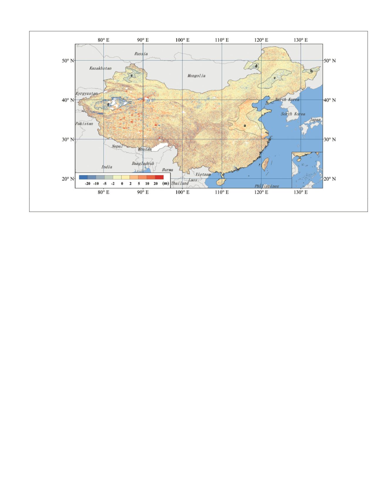
The spatial distribution of the
SRTM
elevation error across
China is shown in Plate 1, in which positive errors indicated
that the
SRTM
elevation was greater than that in
Hc-DEM
for the
same position, and negative errors indicated that the
SRTM
elevation was lower than that in
Hc-DEM
. Larger errors primar-
ily occurred in the mountainous areas with complex terrains
whereas smaller errors primarily occurred in the flat areas.
The positive errors were concentrated in the North China
Plain and the plains in the mid-and lower-reaches of the
Yangtze River (region labeled with an “a” in Plate 1), where
the land is flat and urban areas are densely distributed, so the
main source of error was the height of buildings. The negative
errors were concentrated in the Northeast Plain (region la-
beled with a “b” in Plate 1), the Sanjiang Plain (region labeled
with a “c” in Plate 1), and the Horqin region (region labeled
with a “d” in Plate 1) in northeast China, the Junggar Basin
(region labeled with an “e” in Plate 1), and the Tarim Basin
(region labeled with a “f” in Plate 1) in Xinjiang province.
These areas are dominated by desert and wetland landscapes,
and the wetlands are normally frozen in February (the month
that the shuttle flew the
SRTM
mission) with the land surface
covered by ice. It is therefore very likely that the main source
of elevation error was the penetration of the radar signals
into the ground. In other widely spread mountain-dominated
areas, the variation of
SRTM
data error was much greater.
The
SRTM
error for the entire sample ranged from −1,224.0
m to 1,195.2 m. For the whole of China, the number of points
whose absolute error was greater than 16 m accounted oly
for 1.75 percent of the sample. Figure 7 shows the frequency
distribution of the elevation error of 90 percent of the sample
points, which indicated a clearly symmetrical distribution
with errors concentrated in the vicinity of 0 m and ranging
from −7.4 m to 7.4 m, which was significantly better than that
originally specified for the
SRTM
error. The mean error using
90 percent of the sample points was −0.023 m.
The Obvious Abnormalities
There were some areas with clearly abnormal elevation infor-
mation in the
SRTM
data. These were almost certainly caused
by the impact of the land surface on radar signals and the data
processing. The characteristics of these areas differed greatly
from the surrounding normal areas, and these differences
could be observed directly. The cell values in these areas were
not only greatly different from the true elevation, but also
failed to present the structure of the land surface as mea-
sured (for example) by slope and aspect. Figure 8 shows one
example of an abnormality expressed in the form of elevation,
slope and aspect compared with surrounding normal data.
For the whole of China, the obvious abnormalities in the
SRTM
data included large continuous areas of “vague topogra-
phy” and local “elevation anomalies”. The regions suffering
from the issue of “vague topography” were larger with areas
approximately from 25.6 km
2
to 2045.8 km
2
. The topographic
relief in these areas was lower than the surrounding areas and
displayed missing details, and the topographic attributes ap-
peared vague or even false (Figure 9a). The regions suffering
from the issue of “elevation anomalies” were smaller with areas
approximately from 0.08 km
2
to 0.71 km
2
, and they appeared as
non-existent “isolated peaks” or “deep sinks” (Figure 9b).
Table 1 shows that the total number of sample points with
Plate 1. Spatial distribution of SRTM error in China. Positive errors are concentrated in the region labeled with 'a', while negative errors
are concentrated in the regions labeled with “b”, “c”, “d”,“e”, and “f”.
PHOTOGRAMMETRIC ENGINEERING & REMOTE SENSING
February 2016
141


