for selecting texture features suitable for image classification.
However, applying these algorithms one by one, those used at
the preprocessing stage in particular, can be time-consuming.
Since results reported from most of these measurements tend
to be consistent, future studies will consider automating this
process for an efficient textural analysis that can be easily
adopted in another study area and/or with a different dataset.
In general, all measurement criteria are able to highlight sev-
eral stages a fractal texture may evolve through in its feature
extraction from window sizes ranging from 13 to 61 pixels
for the Landsat multispectral bands. It is observed the fractal
texture would become stable at the windows of 27 to 31 and
may appear similar to a real fractal at windows of 33 – 47/49
and again 49/51 – 59. Among all the window sizes being con-
sidered, the optimal window size for creating texture features
best suited for the
ML
classification is found to be 31.
This paper has demonstrated the limitations of fractal-
based texture features involving the use of the medium spatial
resolution image and the traditional
ML
algorithm on urban
classification. This kind of information fails to support the
identification of most urban classes with the only exception
of medium- and low-density residential. As a result, the best
way to utilize this information for the
ML
-based urban clas-
sification is to consider combining the best results from both
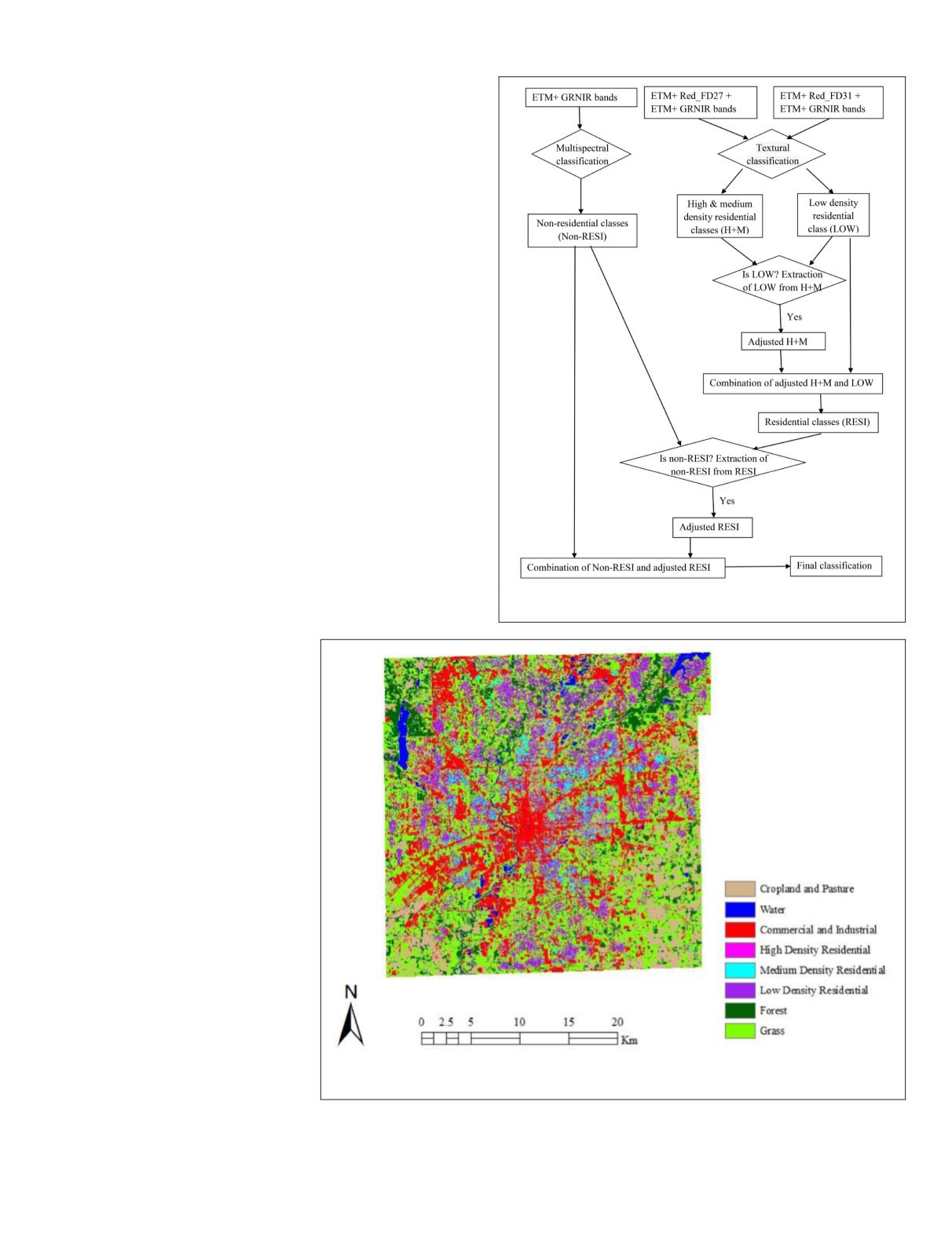
spectral and textural classifications. To this end, a hybrid
classification was performed through a series of expert-rules
and the procedure was illustrated in Figure 10.
Specifically, this classification only considered the fractal
texture based on the 27 and 31 moving windows for the
medium- and low-density residential categories, respectively,
that report the best classification results for the two classes,
while other
LULC
groups were derived by using pure spectral
information. The output classified map is displayed in Figure
11. The accuracy assessment results showed that the clas-
sification for water, commercial
and industrial, medium density
residential, and forest are particu-
larly successful (Table 3b). How-
ever, with the zero accuracy from
the high density residential, the
overall accuracy is still not high
(76.25%). Therefore, the potential
of the fractal-based texture derived
by the triangular prism method on
the per-pixel urban classification
can only be extended if a high spa-
tial resolution image is used, and/
or a data with coarser radiometric
resolution, and/or the use of more
texture features (such as those
created by using the threshold win-
dows), and/or advance level image
classification algorithms (e.g.,
object-based, artificial neural net-
work, decision tree with machine
learning, support vector machines,
and random forests), which will be
considered in future studies.
Acknowledgments
This research was supported by
the “Dean’s 2014 Summer Re-
search Grant” from the College of
Social and Behavioral Sciences at
the University of Northern Iowa
(
UNI
). The authors also thank Mr.
Jonathan Voss from the Geoinformatics Training, Research,
Education, and Extension Center at
UNI
for his help in the
implementation of the algorithms and the editor and the
anonymous reviewers for their thoughtful review and con-
structive comments.
Figure 11. Land use and cover in the Marion County in 2000 based on integration of
texture images derived from the triangular prism fractal algorithm.
Figure 10. Procedure of the hybrid classification based on the
integration of fractal-based texture with the spectral images.
PHOTOGRAMMETRIC ENGINEERING & REMOTE SENSING
November 2018
709


