Study Area
China has a great wealth of lake resources over a great spatial
extent (75° to135° E, 18° to 53° N) and altitudinal range from
the Turpan Desert (156 m below sea level) to the Tibetan Pla-
teau, across a large climatic range from the tropical to subarc-
tic/alpine (Wang and Dou, 1998). The formation, distribution,
and changes of these lakes are closely associated with the great
diversity of climatic, geographic, and socioeconomic condi-
tions in China. The diverse natural and human factors among
different regions have driven profound and complex changes
in the lake systems in China. Therefore, China’s lakes are com-
monly divided into five zones when considering the regional
climates, geomorphological conditions, and political boundar-
ies (Jiang
et al.,
, 2017; Ma
et al.,
2010; Wang and Dou, 1998).
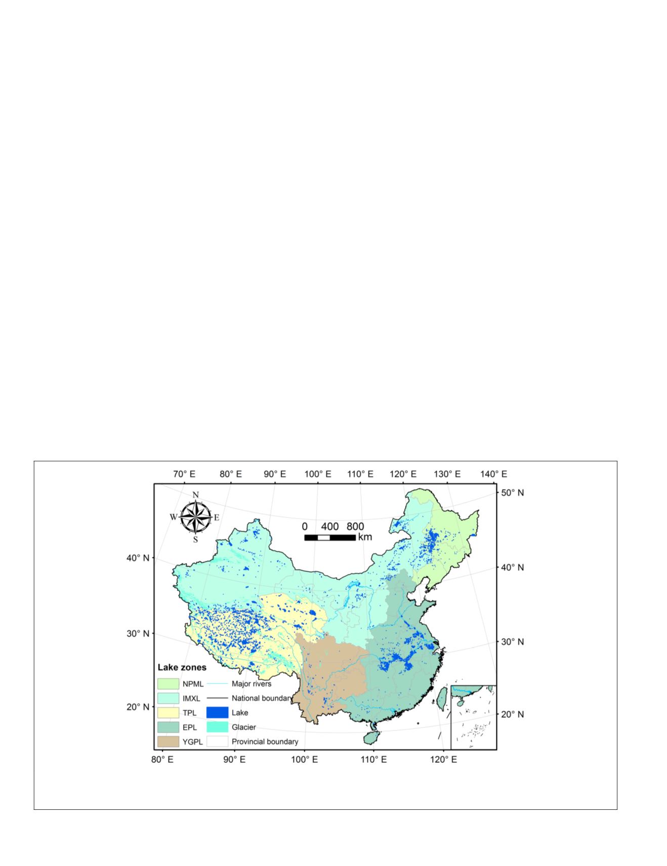
The five lake zones are (Figure 1): Northeast Plain and Moun-
tain Lake-zone (
NPML
), Inner Mongolia-Xin Jiang Lake-zone
(
IMXL
), Tibetan Plateau Lake-zone (
TPL
), Eastern Plain Lake-
zone (
EPL
), and Yunnan-Guizhou Plateau Lake-zone (
YGPL
).
Data and Methods
Development of China’s Multitemporal Lake Database
The surface water extent of all the lakes across China was
extracted from the recent global surface water datasets, which
were produced based on Google Earth Engine
®
(
GEE
) platform
using three million Landsat satellite images between 1984 and
2015 (Pekel
et al.,
, 2016). These datasets map the extent and
change of surface water on monthly time scale over the past
three decades, and show a satisfactory performance in terms
of the accuracy of water extraction, with the overall errors
of omission less than 5% and errors of commission less than
1%. The monthly water history collection, containing the
entire history of water detection for each month in the past 32
years, can be accessed and used in the
GEE
platform (
https://
earthengine.google.com/
).
The surface areas of all the lakes in China for the seven
episodes (i.e., 1985, 1990, 1995, 2000, 2005, 2010, and 2015)
were delineated from the monthly global surface water data-
sets through visual interpretation and manual digitalization.
The water maps acquired in at least three years (primarily
within ±1 years of the mapping years) were used for each
study period due to the limited availability of cloud-free data
for a given year covering the entire China (Ma
et al.,
, 2010;
Yang and Lu, 2014). To reduce the effect of seasonal variabil-
ity on lake water area, the surface water maps within in the
wet season for each lake-zone of China. Specially, the data
from September to November were chosen for the
TPL
zone
(Zhang
et al.
, 2017a; Zhang
et al.
, 2017b), the maps from June
to September were collected for the
IMXL
and
NPML
zones
(Liu
et al.,
, 2013; Tao
et al.
, 2015), and the images from June
to October were selected for the
EPL
and
YGPL
zones (Xie
et
al.
, 2017). The selected water maps were first converted into
polygons with contiguous water pixels, and these polygons
of water bodies were then visually classified into two classes:
natural lakes and other water bodies (e.g., artificial ponds,
reservoirs, and rivers). Subsequently, the detected lake poly-
gons were carefully modified by means of quality assurance
and quality control (
QA/QC
) procedures, including: (1) manual
correction for each lake boundary by visual inspection against
Google Earth high-resolution images; (2) topology checking
for mapped lakes, e.g., removal of duplicate or overlapped
polygons, and combination of the dissected polygons due to a
bridge or other barriers; and (3) cross-validation and compari-
son of the mapped lakes for the seven episodes referring to
published literature and public datasets. The manual editing
procedures need a large amount of human labor, but are es-
sential to guarantee the accuracy of lake mapping (Ma
et al.,
,
2010, Nie
et al.,
, 2017, Yang and Lu, 2014). Following the
QA/
QC
procedures, the surface areas, altitudinal values, and ad-
ministrative divisions of the mapped lakes (
≥
1 km
2
) were cal-
culated using ArcGIS 10.3
®
software. In this study, we focused
Figure 1. Distribution of lakes and the associated five lake zones in China, including Northeast Plain and Mountain Lake-
zone (
NPML
), Inner Mongolia-Xin Jiang Lake-zone (
IMXL
), Tibetan Plateau Lake-zone (
TPL
), Eastern Plain Lake-zone (
EPL
), and
Yunnan-Guizhou Plateau Lake-zone (
YGPL
). The inset in the lower right corner shows the Nansha Islands of China.
658
October 2018
PHOTOGRAMMETRIC ENGINEERING & REMOTE SENSING


