PHOTOGRAMMETRIC ENGINEERING & REMOTE SENSING
July 2020
409
SECTOR
INSIGHT:
.
com
E
ducation
and
P
rofessional
D
evelopment
in
the
G
eospatial
I
nformation
S
cience
and
T
echnology
C
ommunity
Mozhdeh Shahbazi, PhD, PEng, University of Calgary
How Good is that Gear? Drones versus Surveyors!
The integration of three-dimensional (3D) vision in drones or
unmanned aerial vehicles (UAVs), has contributed a great deal
to improving fine-scale mapping and monitoring applications.
Passive imaging systems have been the most popular technol-
ogies used in this regard. This is mainly due to the availabil-
ity of off-the-shelf, low cost, and light-weight digital cameras.
Advancements in photogrammetry and computational stereo
vision have also fostered this popularity (Abdullah, 2019 ).
As a survey engineer, a photogrammetric engineer, and a com-
puter-vision scientist, I have given and received many debatable
comments about these technologies. A question that it is still be-
ing debated by many stakeholders is this: can drone-photogram-
metry result in survey-grade topographic products? The answer
to this question cannot be summarized in a single word as each
term used in this question is itself interpretable in several ways.
In this column, we take a closer look at this question.
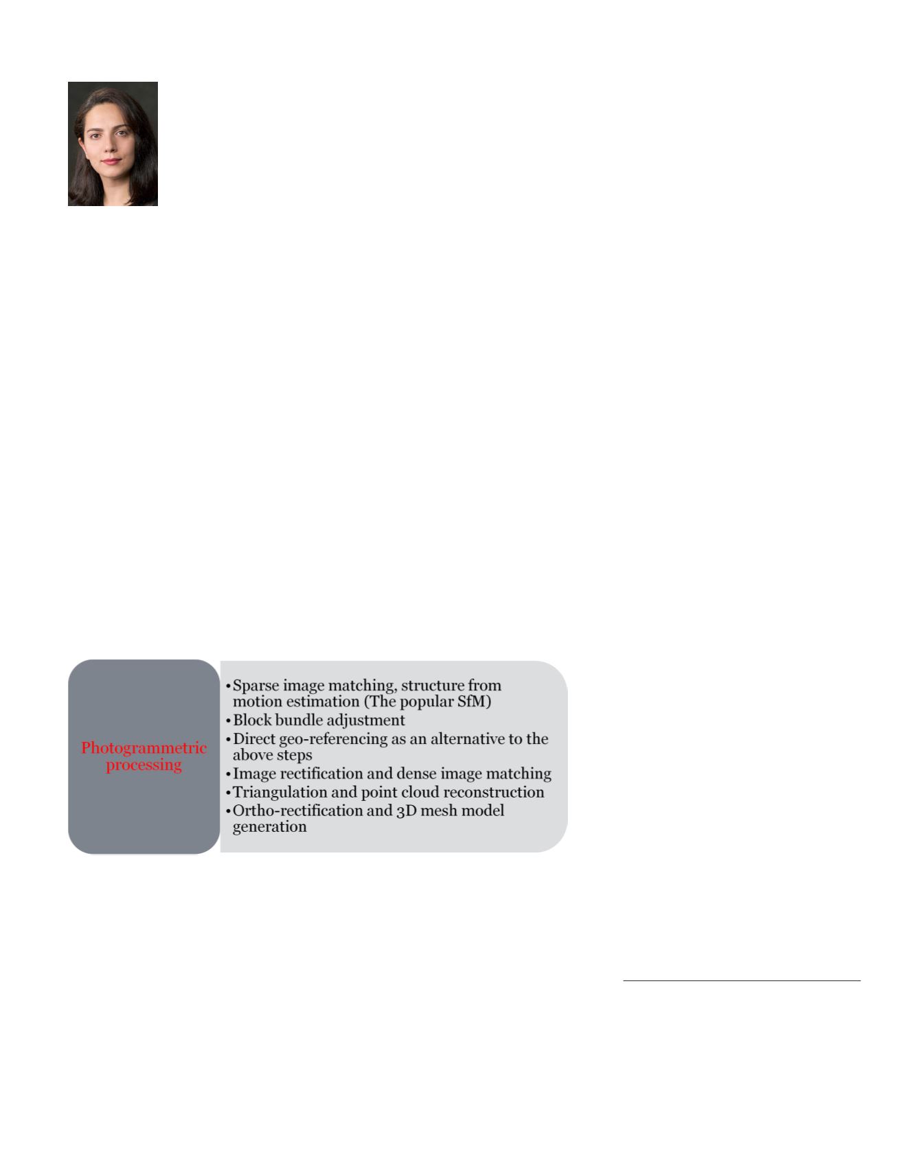
First, we review the main steps involved in the procedure of
turning images into 3D topographic products (Figure 1). This
workflow is more or less the backbone of any black-box com-
mercial software or open-source solution available.
Drone Platforms
A conventional drone system for geospatial applications can
be broken down into three discussable components: the plat-
form, the navigation system, and the imaging sensor. Regard-
ing the platform, the minimum specifications to consider are
the payload capacity, endurance, degree of autonomy, ease
of operation, and, last but not least, compliance with various
regulations.
Navigation Sensors
GNSS-aided inertial navigation sensors are commonly de-
ployed in drone-photogrammetry systems for two purposes: au-
to-piloting the platform and, optionally,
georeferencing
the
images. In most systems, an independent navigation system is
dedicated to the latter. Georeferencing means determining the
external orientation parameters of the images resolved in the
mapping reference coordinate system. It can be performed in
three ways: indirect georeferencing (InDG), direct georeferenc-
ing (DG), and integrated sensor orientation (ISO).
In InDG, georeferencing is performed by adding the obser-
vations of ground control points (GCPs) to the block bundle
adjustment. Essential factors in the success of this method
include the quality of the GCPs, their number, and their
geometric distribution. The accuracy of GCPs dictates the
achievable georeferencing accuracy; the georeferencing ac-
curacy cannot supersede the average GCP accuracy. Geo-
referencing accuracy should not be confused with the recon-
struction accuracy explained below. The only way to measure
the georeferencing accuracy is to establish a fair amount of
well-distributed ground checkpoints. Comparing their abso-
lute measured coordinates with their photo-estimated coor-
dinates yield a measure of georeferencing accuracy. In some
commercial software, e.g. Pix4D Mapper, a
variable is reported after initial processing,
known as GCP error. It is worth mention-
ing that GCP error simply summarizes the
difference between the observed coordinates
and adjusted coordinates of the GCPs. High
GCP errors can indicate either a gross error
or an issue with the block bundle adjust-
ment. Thus, a low GCP error should by no
means be interpreted as high georeferencing
accuracy. This is, unfortunately, a common
mistake made by service providers when dis-
cussing their data quality.
In traditional airborne photogrammetry, the best configuration
for GCPs is to set full control points at the corners and along the
borders of the site, and height control points every 4-6 models
and every 2-4 strips (Figure 2). However, in drone photogram-
Figure 1. Steps in photogrammetric processing.
Photogrammetric Engineering & Remote Sensing
Vol. 86, No. 7, July 2020, pp. 409–410.
0099-1112/20/409–410
© 2020 American Society for Photogrammetry
and Remote Sensing
doi: 10.14358/PERS.86.7.409


