cover is dense (Magnusson
et al
., 2007; Ni-Meister
et al
.,
2001; Su and Bork, 2006). This was evident at the
WC
and
ZZ
plots where ground height is overestimated by <2 m for all
simulated pulse densities (Figure 4E). However at the
RC
area,
erroneous ground models are caused by the minimal number
of returns that penetrate through the upper canopy (Takahashi
et al
., 2008). For example at all pulse densities <2% of returns
are classified as ground, which for the pulse density <0.5 pl
m
-2
results in an average of ~3 identified ground returns in the
plot area. In reality, a number of simulations had no returns
classified as ground which led to the failure of metric calcula-
tion (Figure 7). The effect of increasing flying height to attain
a lower sampling frequency will only exacerbate poor pen-
etration of pulses to the ground owing to a reduction in pulse
intensity (Goodwin
et al
., 2006; Takahashi
et al
., 2008). A
comparison of the mean height of returns classified as ground
for low pulse density datasets reveals that points within the
canopy were miss-classified. This increases the height of the
ground layer (Figure 4E) and propagates to estimation errors
in all metrics. It is acknowledged that a generic approach, us-
ing commonly available software, was taken when classifying
ground returns and a customized solution may have identi-
fied the ground surface more accurately (Evans and Hudak,
2007; Tinkham
et al
., 2011). Nevertheless, for large area ac-
quisitions (e.g., regional to continental transects) where many
different vegetation and terrain types maybe encountered, a
bespoke solution for a particular scenario may not be feasible
or warranted. The opposite is apparent at study areas where
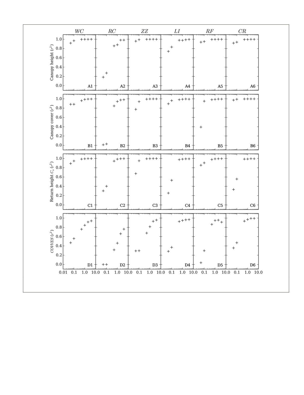
Figure 5. Coefficient of determination where the independent variable was (A) canopy height, (B) canopy cover, (C) return height coef-
ficient of variation (
C
v
), and (D)
COVVES
at six different pulse densities (0.05 to 4 pl m
-2
). The dependent variable was the metric derived
from a pulse density of 10 pl m
-2
.
PHOTOGRAMMETRIC ENGINEERING & REMOTE SENSING
August 2015
631


