et al
., 2006), Scale-invariant Feature Transformation (
SIFT
)
(Lowe, 2004), and Binary Robust Invariant Scalable Keypoints
(
BRISK
) (Leutenegger
et al
., 2011) to name a few. Of these,
SIFT
has been one of the most established matching algorithm used
in photogrammetry and remote sensing (Aguilera
et al
., 2012;
de Matías
et al
., 2009; Lingua
et al
., 2009; Sima
et al
., 2012; Yi
et al
., 2008).
The purpose of this paper is to report new work on the
semi-automatic co-registration and spectral concatenation of
panoramic
VNIR
and
SWIR
ground-based hyperspectral images
to obtain continuous
VNIR
+
SWIR
image spectra. There are
two primary objectives of this work: (1) to evaluate multiple
approaches of selecting input images for homologous point
extraction in
SIFT
, and (2) implement and compare different
techniques for spatial co-registration of panoramic ground-
based hyperspectral images. A secondary objective is to
demonstrate the advantage of combining spectral data from
the two hyperspectral cameras in lithological mapping of
near-vertical geological outcrops.
Materials and Methods
Study Area
The study area in the Goldstrike District is around 56 km (35
mi.) northwest of St. George in Washington County, Utah (Fig-
ure 1). The scanned exposure is a part of an old, reclaimed
open-pit mine, approximately 70 m long, 6 m high, and hosts
of both the upper and lower members of the Claron Forma-
tion. The southeasterly exposure provides excellent illumina-
tion conditions resulting in less shadow except rock surface
relief. Along with the hyperspectral images, representative
rock samples were collected from the accessible parts of the
exposure for the purpose of comparison.
Instrumentation and Data Collection
The ground-based imaging system employs two hyperspectral
cameras from Spectral Imaging Ltd. (SpecIm, Finland). Speci-
fications of the cameras are given in Table 1.
The hyperspectral images were collected under clear-sky
conditions on 29 September between 10:30 am and 12:30
pm local time with cameras mounted on a rotating stage and
tripod. The fore-lenses provided 28.9° field-of-view (
FOV
) for
VNIR
camera and 24°
FOV
for
SWIR
camera which result in im-
ages with at-nadir pixel sizes of approximately 26.6 mm (
SWIR
)
and 10.4 mm (
VNIR
, without spatial binning) at 20 m distance.
During outcrop hyperspectral data collection, a white refer-
ence panel made from polytetrafluoroethylene (
PTFE
) similar
to Spectralon
®
and two custom-made calibration panels with
known reflectance (~3% dark and ~30% gray toned) (Okyay
et al
., 2016) were placed parallel to the outcrop surface within
the cameras’
FOV
. Prior to hyperspectral data collection, initial
scans were performed to determine the best exposure (integra-
tion time). The integration times were adjusted so that pixels
with the highest reflectance (usual-
ly from the white reference panel)
are slightly lower than saturation
employing the full dynamic ranges
of the cameras. Following the final
data collection, dark images were
acquired with camera aperture
closed using the same integration
times for the purpose of removing
the dark current signal from the
hyperspectral data.
A FieldSpec Pro spectroradi-
ometer from Analytical Spectral
Devices, Inc. (
ASD
) was used for
laboratory (non-imaging) reflec-
tance spectroscopic analysis of
collected rock samples. The spec-
troradiometer operates in full-range
collecting data in 2,151 channels
over wavelengths from 350 nm to
2,500 nm with 1.4 nm and 2 nm
sampling interval,
VNIR
and
SWIR
,
respectively. The spectroscopy
data were collected using a bare
fiber optic cable with 25°
FOV
at-
tached to a contact probe with a
broadband direct-current light. The
spectroradiometer was optimized
and calibrated using a Labsphere
Spectralon
®
diffuse reflectance
standard and dark current signal
measured internally by the instru-
ment. Representative reflectance
spectrum of each sample was
calculated as the average of three
replicate spectra collected from an
area of 3.6 cm
2
.
Image Preprocessing
The raw hyperspectral images re-
quire preprocessing which include
dark current signal removal, image/
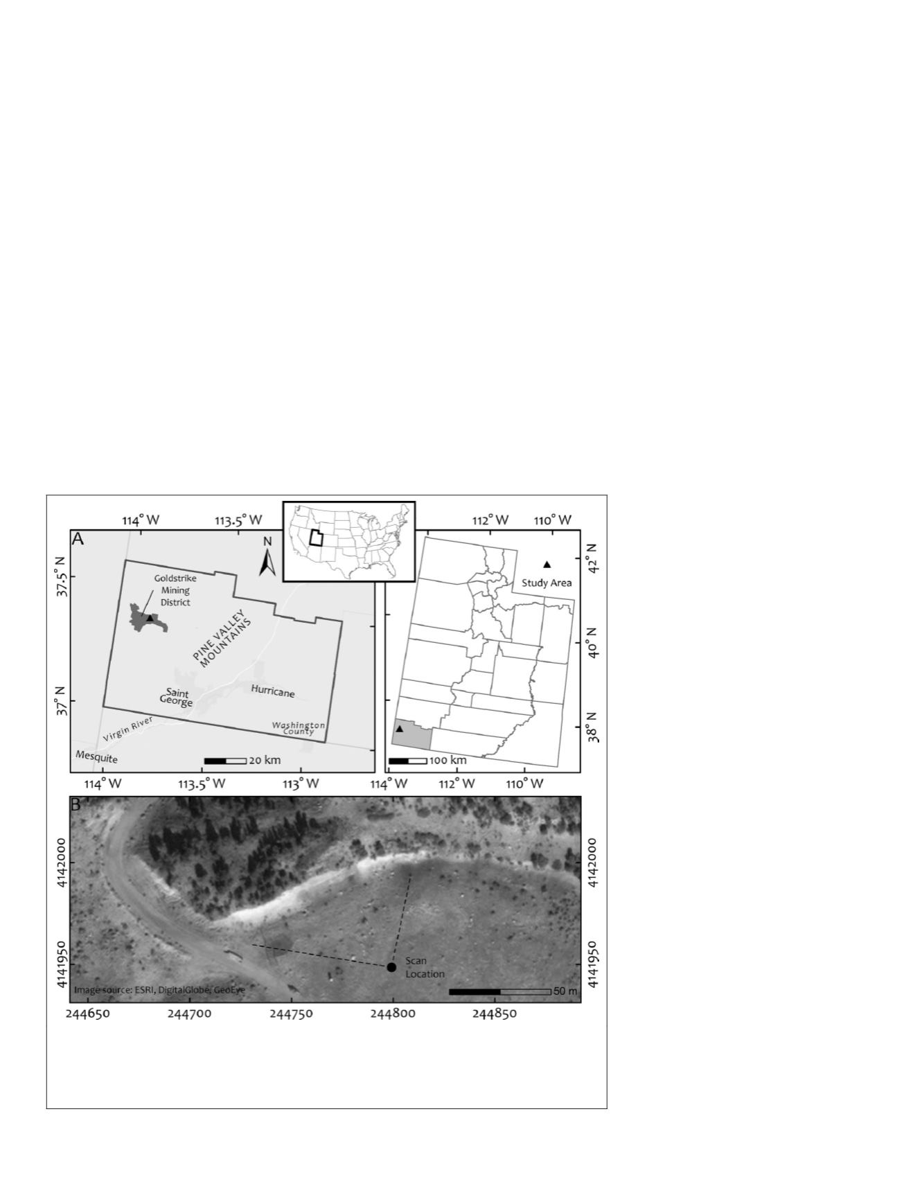
Figure 1. (A) Location of the study area in Goldstrike mining district, Washington
County, Utah,
USA
, and (B) High-resolution satellite imagery of the imaged outcrop.
Coordinates are given in (A) geographic coordinate system (Lambert Azimuthal equal-
area projection) and (B) Universal Transverse Mercator (
UTM
) projection (
NAD
1983 -
Zone 12N).
782
December 2018
PHOTOGRAMMETRIC ENGINEERING & REMOTE SENSING


