IS
derived from traditional remote sensing imagery contain
physical characteristics of
IS
and basic map form, while social
features generated from social data can provide abundant
social information. Our protocol is shown to perform well in
a case study focused on Guangzhou urban region in China, in
which the overall
RMSE
reaches 10.98% and 10.90% for pixel
level and parcel level, respectively. Though parcel-based
IS
map lost abundant details and has a relative lower accuracy
comparing with pixel-based
IS
map, its social functions are
well performed. Parcel-based
IS
map can be of great help to
further investigation, such as detailed land use classification,
built-up area extraction, and land use real-time monitoring.
It is promising to apply this technique of both pixel-level and
parcel-level into
IS
estimation in a relatively short time, espe-
cially in the suburban area and fast-growing countries.
There are several aspects in the proposed method that could
be improved in future work. For instance, in this study, we
used
POI
datasets collected from web maps, which are mostly
located along the roads rather than uniformly distribute over
the study area. This can lead to the inaccurate impervious frac-
tions, as the fractions of pixels along the roads may be higher
than the pixels inside, even if they belong to a same building.
Volunteered
POI
/check-in data offered by social media plat-
forms exhibit the potential to cover the shortage of
POI
data.
Different from
POI
data, volunteered
POI
data are generated
based on the location of users, but the social properties of these
POIs
are generally not defined. Additional efforts can be made
by focusing on the identification and clustering of volunteered
POI
datasets to rationalize the impervious result. Another line
of improvement is related to our utilization of a multivariable
linear model for data fusion. Additional nonlinear models
could be tested in future developments, like those based on
neural networks, fuzzy set theories, Bayesian techniques, etc.,
(Zhang, 2010). These models exhibit potential to achieve even
better performance in impervious surface mapping.
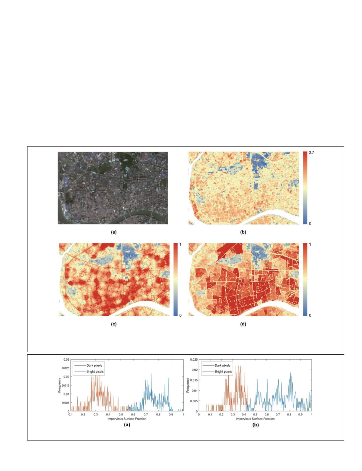
Figure 9. (a) Part of original imagery, (b) Physical features (initial impervious fractions derived by remote sensing imagery),
(c) Pixel-based impervious surface estimation, (d) Parcel-based impervious surface estimation. The influences caused by
urban greening are well avoided.
Figure 10. Histograms of bright imperviousness and dark imperviousness of (a) pixel-based result, and (b) parcel-based result.
PHOTOGRAMMETRIC ENGINEERING & REMOTE SENSING
December 2018
779


