registration that can reflect the similarity of the grayscale
differences between two images; the smaller the
SSD
, the
more similar the two images are. Although the
SSD
has high
computational efficiency, it cannot accurately adapt to multi-
spectral remote sensing images. The
NCC
is a classical similar-
ity measure in image registration. It has been widely used for
single-spectral image registration due to its linear invariance
for grayscale changes and high computational efficiency
(Inglada
et al.
2004). However, it performs poorly in nonlinear
radiometric differences (Hel-Or
et al.
2014). By contrast, the
MI is more resistant to complex nonlinear grayscale changes
and is gradually used for multisource image registration
(Brunner
et al.
2010; Cole-Rhodes
et al.
2003; Suri and Rein-
artz 2010). Unfortunately, MI-based image matching methods
have numerous calculations, thereby limiting its application.
In summary, these similarity measures are not well suited for
handling radiometric distortions among multisource images,
because they are more stable for intensity changes. Therefore,
previous researchers have applied these metrics to image
descriptors, such as wavelet-like (Hong
et al.
2008; Murphy
et al.
2016) and gradient features (Ravanbakhsh
et al.
2013),
to improve registration performance. However, these features
cannot reflect the common properties of multisource images.
Recently, shape features have been integrated into simi-
larity descriptors for image matching and received better
registration results compared with conventional similarity
measures in multisource image processing (Fu
et al.
2019;
Zimmer
et al.
2019). The histogram of the oriented phase
congruency (HOPC) based on shape features is successfully
used to match the multisource remote sensing images (Ye
et al.
2017). Generic and automatic Markov Random Field
is defined by grayscale and gradient statistical information
(Yan
et al.
2018). The main ideal of robust center-symmetric
local ternary pattern (
CSLTP
) based self-similarity descriptor
is a rotation invariance description strategy on local correla-
tion surface (Chen
et al.
2018). Extended phase correlation
algorithm based on log Gabor filtering (
LGEPC
) focuses on two
problems: 1) significant nonlinear radiometric differences
and 2) large-scale differences between image pairs. (Xie
et al.
2019). These methods are robust to the significant nonlinear
intensity differences between multisource remote sensing
images. However, they are may limited to
information.
In an appropriate region, the terrain sh
similar between visible and
SAR
images (c
similarities) regardless of whether they have highly differ-
ent intensity characteristics. Inspired by this discovery, this
study proposes a multispectral image matching strategy based
on scene shape similarity. Therefore, shape context can be
applied to describe scene contour structures (Belongie
et al.
2001). Accordingly, a novel feature descriptor is defined by
the shape features that can describe the scene shape struc-
tures of the images. The descriptor, namely the scene shape
similarity feature (
SSSF
), can be efficiently calculated using
the shape context algorithm over the image. The
SSSF
descrip-
tor reflects the terrain shape structural properties of a certain
region in images, which are robust to the intensity pattern
between two images. The
SSSF
descriptor can be calculated for
the reference and the sensed image. The
NCC
of the
SSSF
de-
scriptor is then used to define the similarity measure, called
the
SSSF
ncc
, which is used to extract tie points via a template-
matching method. Finally, the
PL
transform is used to rectify
the sensed image. The main contribution of this study is the
definition of a novel scene shape similarity measure named
SSSF
ncc
, which can handle nonlinear grayscale differences
between multisource images.
The proposed method is introduced in the following parts:
Section “Methodology” describes the methodology, including
shape context, the
SSSF
descriptor, similarity measures based
on the
SSSF
descriptor, and multisource registration methods
based on
SSSF
ncc
. Then, Section “Experiments and Evaluation”
presents the experiments and evaluates the results. Section
“Discussion” summarizes the conclusions and discussions.
Methodology
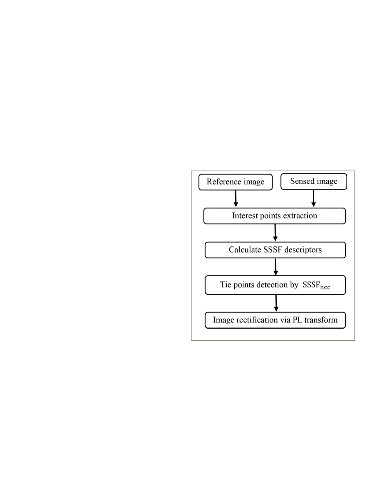
Image registration aims to capture the optimal alignment un-
der the spatial coordinate system between multisource remote
sensing images. This study proposes a robust multispectral re-
mote sensing image registration method based on scene shape
similarity. In this method, the blocked Harris operator is first
applied to detect feature points in the reference image. Then,
the novel
SSSF
descriptor is designed using the shape context
algorithm. Furthermore, a similarity measure defined by the
SSSF
descriptor is applied to extract tie points via the template
matching method. A global consistency check method is then
used to remove the mismatched tie points. Finally, the
PL
transform model is selected to rectify the remote sensing imag-
es. Figure 1 shows the key procedure of the proposed method.
Figure 1. Flow chart of the proposed method.
Shape Context
Shape context is a very popular shape descriptor and is
mostly used for shape matching and target recognition. It
adopts a feature description method based on shape contours,
which uses the histogram to describe the shape features in the
log polar coordinate system to reflect the contour’s distribu-
tion of sampling points. In the overall framework, the shape
context counts the context information of each point in a two-
point set and compares the context information between each
point to obtain the closest set of permutations. Moreover, the
correspondence points of the second point set can be found
for each point of the first point set. The basic principle of the
shape context is as follows:
1. For a given shape, the shape contour is obtained through
the edge detection operator (e.g., canny operator). Then, the
contour of the given shape is sampled to obtain a set of dis-
crete points
p
1
,
p
2
, …,
p
n
. Figures 2a and 2b show this detail.
726
October 2019
PHOTOGRAMMETRIC ENGINEERING & REMOTE SENSING


