Point-Cloud Assessment: Boresight Correction and LSM Refinement
Improvements
Table 2 summarizes the accuracy of the point clouds com-
puted from experiments A through D. The mean, standard
deviation, and
RMSE
of the altimetric (
∆
h
) and planimetric (
∆
E
and
∆
N
) discrepancies between the point clouds and the
reference data were computed. The altimetric quality control
described earlier was performed in the four experiments
considering the same 13
GCPs
as reference. The planimetric
control was applied with the same sev
3D and flat-plane targets and building
experiments. The results presented in
improvements on the point-cloud accu
correction and the proposed
LSM
refinement are applied with
the postprocessing synchronization.
Experiment A shows an
RMSE
of 14.9 cm for the altimetry
and 1.67 m for the planimetry. These results were obtained
applying the postprocessing synchronization method without
correcting systematic errors such as boresight misalignment
between the laser unit and the
IMU
, which explains the meter-
level planimetric error.
Experiment B presents the results of the postprocessing
synchronization technique (see Clock-Difference Estimation
and Off-Line Synchronization) with the
LSM
refinement (see
Refinement by the Least-Squares Method). This correction
improved the planimetric accuracy of the point cloud gener-
ated by 8 cm, when compared to the planimetric
RMSE
from
Experiments A (1.67 m) and B (1.59 m).
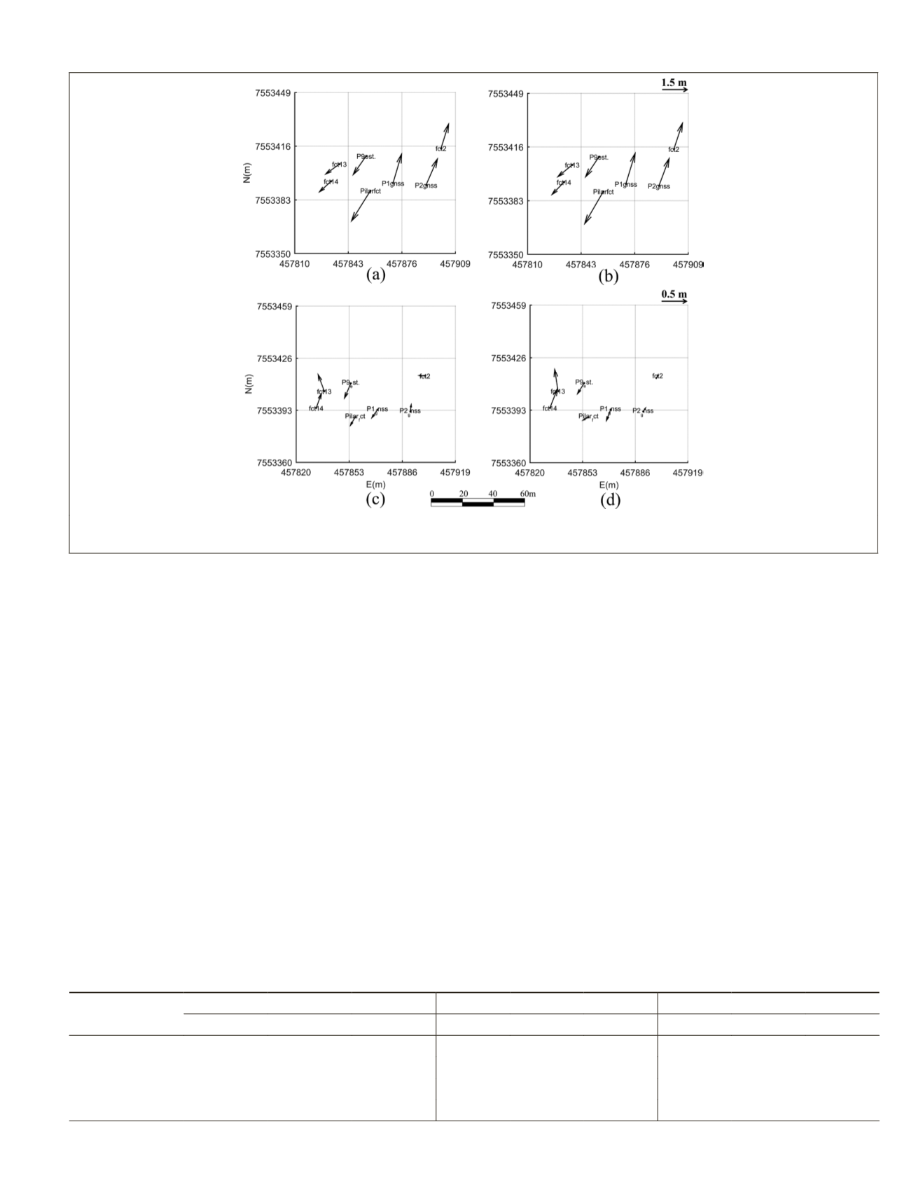
Figure 7 shows the behavior of the errors for Experiments
A through D, considering flight strips 3 and 2 with a vector
plot of the
X
and
Y
errors for each
GCP
as a function of the
E
and
N
coordinates (error scale is graphically shown in the
lower right part of Figure 7). Systematic errors in the plani-
metric coordinates were identified in Experiments A and B, as
stimated means in Table 2. These errors in
re 7a) and B (Figure 7b) can be associated
sight-misalignment correction, which
of these values and quality control after
this correction in Experiments C and D.
A significant improvement in the generated point cloud
with the postprocessing synchronization technique was noted
when the boresight-misalignment correction was employed,
especially in the planimetric coordinates. Comparing Experi-
ments A and C, the planimetric
RMSE
(
∆
E
,
∆
N
) decreased from
1.67 m to 0.28 m (28.1 cm) and the estimation altitudes im-
proved by 2.2 cm. In Experiment D, the point cloud was gen-
erated with postprocessing synchronization combined with
the
LSM
refinement and boresight correction. Improvements
of 84% in the planimetry and 32% in the altimetry were
Table 2. Statistics (in meters) of altimetric and planimetric discrepancies of the point clouds generated in Experiments A
through D.
Experiment
Mean
Standard deviation
Root-mean-square error
∆
E
∆
N
∆
h
∆
E
∆
N
∆
h
∆
E
∆
N
∆
h
A
−0.737
0.723
0.049
0.796
1.594
0.147
0.783
1.477
0.149
B
−0.72
−0.611
0.045
0.786
1.493
0.146
0.773
1.385
0.147
C
−0.115
0.009
−0.081
0.093
0.252
0.101
0.109
0.235
0.127
D
−0.068
−0.064
−0.055
0.104
0.277
0.087
0.102
0.262
0.100
Figure 7. Planimetric residuals on ground control points from (a) Experiment A, (b) Experiment B, (c) Experiment C, and (d)
Experiment D.
PHOTOGRAMMETRIC ENGINEERING & REMOTE SENSING
October 2019
761


