pixels (
δ
8
) in method II, indicating that there are systematic
errors in
GPS/IMU
, but our method can register well. Figure 11
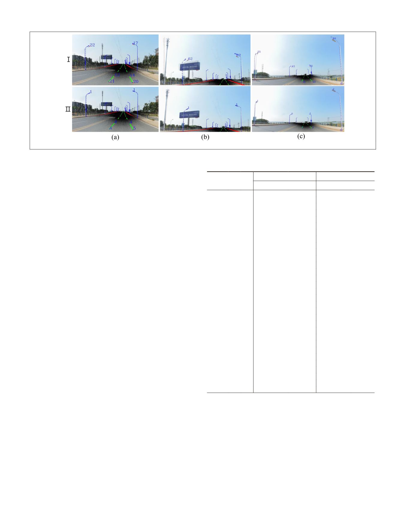
shows some local images of feature points.
Panoramic Image Sequence Registration
To prove the applicability and accuracy of our registration
method, the experiments are performed with a sequence of
panoramic images (nos. 1–31) in this section, and the param-
eters are the same as those previously used. Limited by space,
Figure 12 shows only three local registration results of the
nos. 1, 11, and 22 panoramic images with the two methods.
As shown in Figure 12, our registration method has obvious
optimization effects compared with method I, which was com-
pleted without manual intervention. For quantitative analysis,
Table 3 lists the accuracy analysis of 31 panoramic images.
Table 3 shows that the registration error (
δ
) of method I is
3.5 (no. 2)–30.5 (no. 22) times that of method II and averaged
at 10.8 times. The number of feature points (
n
) is between 7
(no. 31) and 13 (nos. 5, 10, 12, and 27), and the mismatching
feature points are at most two in nos. 7, 8, 16, and 19. Figure
13 shows
δ
i
, and Figure 14 shows
δ
of 31 panoramic images.
As shown in Figures 13 and 14,
δ
i
in 31 panoramic images
is noticeably reduced compared with that of method I, and all
the
δ
are less than 10 pixels with metho
31 panoramic images is 5.84 pixels usin
much less than the 56.24 pixels of meth
ture points
δ
i
larger than 100 pixels with method I, as Figure
15 shows; all are located on the road lamp with close range.
There are large errors about some feature points with meth-
od II, such as 19.72 pixels (no. 2), 17.00 pixels (no. 8), 19.31
pixels (no. 12), 18.87 pixels (no. 23), and so on. All of these
prominent points are the road lane feature points with close
imaging distance; the reasons are as follows: (1) According
to the imaging model of the spherical panoramic image, the
influence of attitude parameters on the upper and lower sides
of the panoramic image is greater than that on the middle,
and position parameters on the panoramic image decrease
with the increase in imaging distance (Zhu 2019). Therefore,
the feature points with close distance and located at the lower
sides of the panoramic image have large registration error.
(2) As shown in Figure 3b, the size of the road lane itself is
0.13 × 6 m, the road lane in the distance is a linear object on
the panoramic image, and these feature points extracted from
LiDAR
points and the panoramic image are corresponding.
However, when the distance is close, the road lane is an area
object, and these feature points cannot strictly satisfy corre-
sponding relations, so the road lane feature points with close
distance may have a large error. (3) These large errors are af-
fected by the panoramic stitching, and some road lane feature
points near the stitching seam may have a large error.
In addition to using pixels (
δ
) to evaluate the registration
accuracy, we can also convert pixels to meters by the spatial
resolution of the panoramic image. Unlike an aerial image,
the object distance has huge differences in the
MMS
pan-
oramic image, resulting in a very different resolution of each
pixel in the image. Take the width of road lane as an example
(the width is 0.13 m). When the road lane is near the imag-
ing position (
ds
< 5 m), the width in the panoramic image is
approximately 60 pixels, so the pixel size on the ground is
approximately 0.002 m. However, when the road lane is away
from the imaging position (
ds
> 30 m), the width is less than
5 pixels, so the pixel size on the ground is greater than 0.026
m. In addition, the pixel size on the ground can be calculated;
the size of the panoramic image in our article is 4000 × 8000
Figure 12. Local registration results of three panoramic images with the two methods. (a) No. 1. (b) No. 11. (c) No. 22.
Table 3. Registration accuracy analysis of 31 panoramic
images (pixels).
No.
m n
Method I
Method II
Maximum
δ
Maximum
δ
1 10 10 48.92
30.75
7.21
4.42
2 10 9
47.20
32.49
19.72
9.19
3 13 12 51.62
33.90
14.14
6.30
4 13 12 85.09
35.64
14.42
6.24
5 13 13 91.98
44.16
11.05
6.07
6 11 11 60.31
40.62
14.42
6.40
7 12 10 74.95
51.24
7.28
4.40
8 13 11 87.11
54.00
17.00
6.30
9 10 10 118.53
67.25
9.06
5.47
10 13 13 162.83
72.38
15.65
6.52
11 9 9
94.76
69.46
7.28
3.21
12 14 13 84.91
65.81
19.31
9.82
13 11 11 93.43
62.75
10.20
6.55
14 10 9 143.27
72.70
9.85
5.30
15 11 11 95.27
66.26
16.12
6.95
16 11 9
94.05
69.53
13.00
6.11
17 11 10 89.11
60.29
10.2
4.89
8.01
42.50
14.04
6.09
39.79
66.19
12.81
5.49
1.32
54.31
7.21
3.73
9.89
52.38
11.4
6.00
22 8 8
89.20
57.18
3.16
1.87
23 8 8
65.80
48.94
18.87
7.89
24 8 8 101.83
58.65
10.82
5.33
25 10 10 71.78
55.42
17.80
7.83
26 11 11 77.47
54.34
7.21
3.72
27 13 13 68.25
51.16
13.04
5.78
28 11 11 157.01
70.94
6.32
4.12
29 11 10 84.39
59.75
16.28
7.64
30 8 8
79.51
64.56
9.85
4.36
31 7 7
96.94
77.98
17.03
6.96
PHOTOGRAMMETRIC ENGINEERING & REMOTE SENSING
November 2019
835


