between the S7 with
RS
on and off. This implies that distor-
tion deviation was higher in the inclined topography.
The results obtained from our
TLS
/
ALS
comparison proce-
dures, which have not been used previously in Korea, provide
a good basis for evaluating the reliability of
UAV
3D
information.
Topographic surveys are more expensive using
TLS
/
ALS
than
using
UAVs
, and although
GNSS
surveys are similar in cost to
UAV
scans, the resulting
DSMs
for a similar field effort are less detailed.
Estimation of Earthworks Using DSMs
To test the accuracy of the
UAV
-based earthworks, a stockpile
volumetric survey was performed, which is generally accu-
rate to within a few percentage points but may be influenced
by the height of earthworks and the accuracy of the surface
model (Draeyer and Strecha 2016).
The volume of each cell in a grid was calculated using formula
V
c
=GSD
2
× (H
t
– H
s
).
(1)
The height of the cell is the difference between the terrain
altitude (H
t
) of the cell at its center and the base altitude (H
s
)
at the cell’s center, and the length and width of the cell cor-
respond to the
GSD
. It is imperative to define and measure cut
volumes (
V
c
, where the terrain is higher than the base surface)
and fill volumes (
V
f
, where the terrain is beneath the base).
The total volume (
V
t
) of the stockpile is given by
V
t
=
V
c
+
V
f
.
(2)
The estimated earthworks volumes are presented in Table 7.
We used
ALS
data to estimate earthwork volumes after
116 days. Before earthworks (3/15/2016) we used
ALS
data.
We estimated earth volume using
ALS DSM
before earthworks
and
UAV DSM
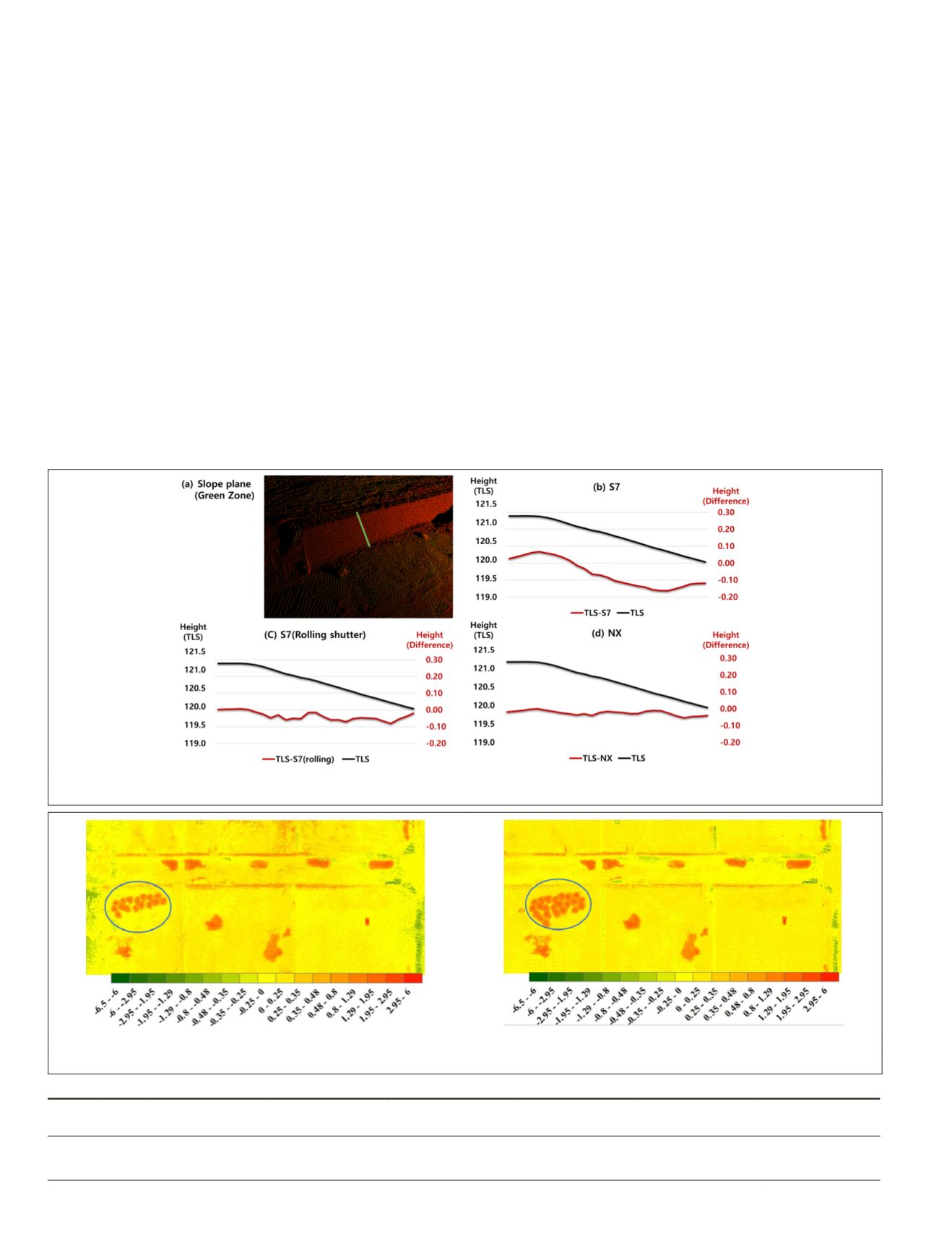
after earthworks. The area inside the blue circle
of Figure 11 shows the earthmoving. Images were captured
sequentially using the
UAV
between 9 am and noon, and only
banking earthworks were underway at the construction site
while the image data were being gathered. To estimate the
earthworks volumes, the size of the study area was limited
to 220 × 100 m. The total earthworks volume increased over
time. In some countries, it is a legal requirement to determine
earthworks volumes to within 3% of overall volume (Raeva
et
al.
2016). However, the precision of measurements is influ-
enced by a variety of factors, including the type of material
excavated at a quarry or construction site and the environ-
mental conditions (Mazhrakov 2007). However, greater preci-
sion is required in the case of smartphone cameras.
Figure 10. Height differences and stand
en terrestrial laser scanning and
UAV
for each camera at the slope plane.
(a) ALS and S7
(b) ALS and NX
Figure 11. Cut and fill conditions (with locations of completed earthworks shown) for airborne laser scanning and (a) S7 and (b)
NX
.
Table 7. Changes in estimated volumes before earthworks (airborne laser scanning) and after (
S7
and
NX
).
Camera Time
Target Area
(m
2
)
Fill Volume
(m
3
)
Cut Volume
(m
3
)
Total Volume
(m
3
)
Estimated
Volume Error (m
3
)
Volume
Accuracy (%)
S7
10:10
22,000
−1,006
23,970
22,964
1,119
4.9
NX 11:16
0
−969
24,409
23,439
726
3.1
896
December 2019
PHOTOGRAMMETRIC ENGINEERING & REMOTE SENSING


